P.Z. 11-2015 Kemp Auto Museum (16861 Chesterfield Airport Road)
NOTICE OF PUBLIC HEARING
CITY OF CHESTERFIELD
PLANNING COMMISSION
NOTICE IS HEREBY GIVEN that the Planning Commission of the City of Chesterfield will hold a Public Hearing on November 23, 2015 at 7:00 p.m. in the City Council Chambers at Chesterfield City Hall, 690 Chesterfield Parkway West, Chesterfield, Missouri 63017.
Said Hearing will be as follows:
P.Z. 11-2015 Kemp Auto Museum (16861 Chesterfield Airport Road): A request for a zoning map amendment from a “PC” Planned Commercial District to a new “PC” Planned Commercial District for 2.65 acres located on the south side of Interstate 64 east of Chesterfield Commons Drive (17T230190).
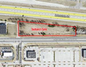
For a larger image of the site, please click HERE.
REQUESTED USES:
- Restaurant, Sit Down
- Coffee Shop
- Commercial Service Facility
- Office, General
- Professional and Technical Service Facility
- Restaurant, Take Out
- Restaurant, Fast Food (without drive through and limited to “fast casual)
- Retail Sales Establishment, Neighborhood
Anyone interested in the proceedings will be given an opportunity to be heard. Copies of the request are available for review in the Department of Public Services at Chesterfield City Hall, 690 Chesterfield Parkway West during weekdays between the hours of 8:30 a.m. and 4:30 p.m. If you should need additional information about this project, please contact Mr. Jonathan Raiche, Senior Planner, by telephone at 636-537-4736 or by email at jraiche@chesterfield.mo.us
CITY OF CHESTERFIELD
Stanley Proctor, Chair
Chesterfield Planning Commission
PROPERTY DESCRIPTION
A tract of land being Adjusted Lot C803 of Boundary Adjustment Plat as recorded in Plat Book 355 Page 647, in U.S. Survey 2031, Township 45 North, Range 4 East of the 5th P.M., City of Chesterfield, St. Louis County, Missouri and being more particularly described as follows:
Beginning at a found iron pipe at the northwest corner of said Adjusted Lot C803; thence along the north line of said lot, S84°06’54”E 766.34 feet to the northeast corner of said Adjusted Lot C803; thence along the east line of said lot S00°24’54”E 109.36 feet to the southeast corner of said Adjusted Lot C803; thence along the south line of said lot S89°35’06”W 761.68 feet to the southwest corner of said Adjusted Lot C803; thence along the west line of said lot N00°25’29”W 193.45 feet to the point of beginning, containing 2.65 acres. Subject to any and all easements, restrictions, conditions, etc. of record.