P.Z. 12-2012 Chesterfield Oaks (Capitol Land)
NOTICE OF PUBLIC HEARING
CITY OF CHESTERFIELD
PLANNING COMMISSION
NOTICE IS HEREBY GIVEN that the Planning Commission of the City of Chesterfield will hold a Public Hearing on Monday, October 8, 2012, at 7:00 PM, in the Council Chambers at the City Hall, 690 Chesterfield Parkway West, Chesterfield, Missouri 63017. Said hearing will be as follows:
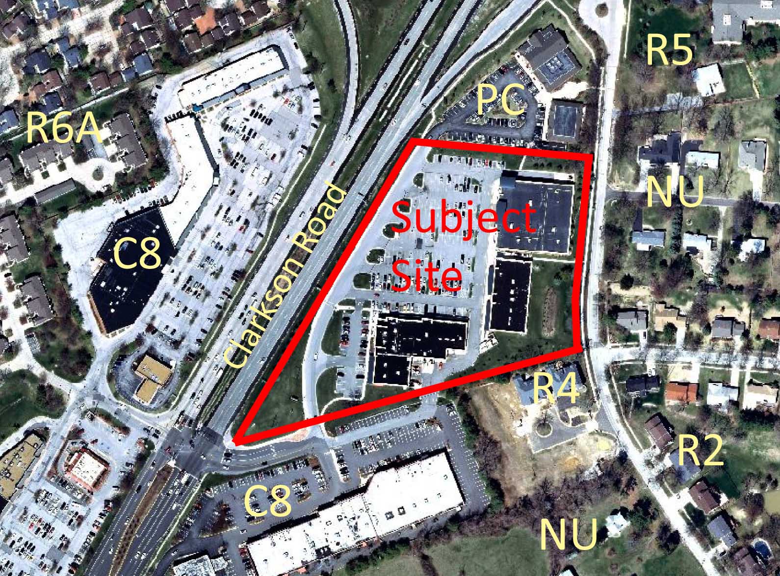
P.Z. 12-2012 Chesterfield Oaks (Capitol Land): A request for an amendment to City of Chesterfield Ordinance 2643 to add the Office, medical land use in a "PC" Planned Commercial District of 6.494 acres in size and located on the east side of Clarkson Road south of its intersection of Chesterfield Parkway and north of its intersection with Baxter Road (19S420415).

For a larger image of the site, please click HERE.
REQUESTED USE:
- Office, medical
Anyone interested in the proceedings will be given an opportunity to be heard. Copies of the request are available for review in the Planning and Development Services Division at the Chesterfield City Hall, 690 Chesterfield Parkway West during weekdays between the hours of 8:30 a.m. and 4:30 p.m. If you should need additional information about this project, please contact Ms. Purvi Patel, Project Planner, by telephone at 636-537-4738 or by email at ppattel@chesterfield.mo.us
CITY OF CHESTERFIELD
Mike Watson, Chair
Chesterfield Planning Commission
Description of Property
A tract of land being all of Lot "A" of Swantner Acres, a subdivision according to the plat thereof recorded in Plat Book 143, page 50 of the St. Louis County Records, part of Parcel 1 and all of Parcel 2 of "A Boundary Adjustment Plat of a Tract of Land in U.S. Survey 2002, Township 45 North, Range 4 East" according to the plat thereof recorded in Plat Book 255, page 52 of the St. Louis County Records, part of a tract of land conveyed to Francis Macalady by deed recorded in Book 8811, page 1587, all of a tract of land conveyed by Francis Macalady by deed recorded in Book 6713, page 2348 and part of a tract of land conveyed to Emil Rauscher by deed recorded in Book 2401, page 634 all of the St. Louis County Records, all being situated in U.S. Survey 2002, Township 45 North, Range 4 East, St. Louis County, Missouri and being more particularly described as follows:
Beginning at a point in the Western line of Baxter Road, 30 feet wide, being the Southeastern corner or tract of land conveyed to Raymond Felling by deed recorded in Book 2285, page 468 of the St. Louis County Records; thence along the Southern line of Felling, South 76 degrees 38 minutes 20 seconds West, 10.54 feet to the Northeastern corner of aforesaid Lot "A" of "Swantner Acres"; thence along the Eastern line of said Lot "A", South 4 degrees 59 minutes 46 seconds West, 106.50 feet to an angle point therein; thence South 5 degreee 04 minutes 14 seconds East, 96.47 feet to the Southeastern corner of said Lot "A"; thence along the Southern line of said Lot "A" and the Southern line of a tract of land conveyed to Caparco Two, Inc. by deed book recorded in Book 10020, page 1926 of the St. Louis County Records, South 72 degrees 57 minutes 29 seconds West, 755.18 feet to a point in the Eastern Right-of-Way of Relocated Route 340 (aka Clarkson Road) as established by deed recorded in Book 8383, page 2153 of the St. Louis County Records; thence along said Eastern Right-of-Way, North 30 degrees 58 minutes 26 seconds East, 45.26 feet to an angle point therein; thence North 24 degrees 07 minutes 52 seconds East, 125.90 feet to an angle point therein; thence continuing along said Right-of-Way and along the Eastern Right-of-Way as established by deeds recorded in Book 8538, page 2270 and Book 8442, page 2359 of the St. Louis County Records, North 30 degrees 58 minutes 26 seconds East, 620.62 feet to a point on the Southern line of property conveyed to Elmer A. Weinrich by deed recorded in Book 2260, page 446 of the St. Louis County Records; thence along said Southern line of Weinrich, South 84 degrees 12 minutes 17 seconds East, 360.24 feet to a point on the Western line of Baxter Road, as aforementioned; thence along said Western line, South 4 degrees 59 minutes 46 seconds West, 224.36 feet to the point of beginning and containing 6.494 Acres (282,860 Square Feet) more or less.
