P.Z. 07-2016 Willows at Brooking Park (Amendment to CUP #31)
NOTICE OF PUBLIC HEARING
CITY OF CHESTERFIELD
PLANNING COMMISSION
NOTICE IS HEREBY GIVEN that the Planning Commission of the City of Chesterfield will hold a Public Hearing on Monday, September 12, 2016 at 7:00 p.m. in the Great Room at DoubleTree by Hilton Hotel, 16625 Swingley Ridge Road, Chesterfield, Missouri 63017.
Said Hearing will be as follows:
P.Z. 07-2016 Willows at Brooking Park (Amendment to CUP #31): A request to amend Conditional Use Permit (CUP) #31 to amend the development conditions in an “R-1” Residence District, “R-3” Residence District, and “FPR1” Flood Plain Residence District for a 26.65 acre tract of land located southwest of the intersection of South Woods Mill Road and Brookings Park Drive. (18Q140361, 18Q140370, 18Q140352, 18Q140077).
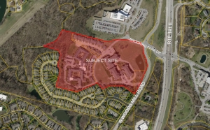
For a larger image of the site, please click HERE.
Anyone interested in the proceedings will be given an opportunity to be heard. Copies of the request are available for review in the Department of Public Services at Chesterfield City Hall, 690 Chesterfield Parkway West during weekdays between the hours of 8:30 a.m. and 4:30 p.m. If you should need additional information about this project, please contact Ms. Cecilia Hernandez, Project Planner, by telephone at 636-537-4738 or by email at chernandez@chesterfield.mo.us
CITY OF CHESTERFIELD
Stanley Proctor, Chair
Chesterfield Planning Commission
PROPERTY DESCRIPTION
Adjusted Lot 1 and part of Adjusted Lot 2 of the Boundary Adjustment Plat of Adjusted Lot 1 and Adjusted Lot 2 of the Boundary Adjustment Plat of Lot 1 and Lot 2 of Brooking Park Village, according to the plat thereof recorded in Plat Book 358 page 165 and 166 and part of a tract of land in Fractional Section 7, Township 45 North, Range 5 East, as per deed recorded in Book 12323 Page 1366 of the St. Louis County Land Records Office in St. Louis County, Missouri being more particularly described as follows:
Beginning along the Eastern line of said Adjusted Lot 2 on the Western right of way line of Highway 141 and being on the Northeast line of the Terraces at Woodsmill Cove Plat One, as recorded in Plat Book 283 Page 88; thence leaving said right of way line along the Southern line of Adjusted Lot 2, North 53 degrees 18 minutes 04 seconds West a distance of 205.84 feet;
Thence North 85 degrees 47 minutes 53 seconds West a distance of 214.77 feet;
Thence South 67 degrees 51 minutes 30 seconds West a distance of 142.31 feet;
Thence North 44 degrees 21 minutes 52 seconds West a distance of 131.80 feet;
Thence South 65 degrees 46 minutes 49 seconds West a distance of 108.33 feet;
Thence South 65 degrees 46 minutes 49 seconds West a distance of 248.80 feet;
Thence North 75 degrees 18 minutes 03 seconds West a distance of 347.46 feet;
Thence North 14 degrees 45 minutes 51 seconds East a distance of 278.96 feet;
Thence North 30 degrees 18 minutes 34 seconds West a distance of 80.67 feet;
Thence North 14 degrees 46 minutes 09 seconds East a distance of 185.74 feet;
Thence North 30 degrees 15 minutes 30 seconds West a distance of 80.65 feet;
Thence North 75 degrees 14 minutes 20 seconds West a distance of 244.04 feet;
Thence North 68 degrees 33 minutes 08 seconds East a distance of 187.32 feet;
Thence North 51 degrees 07 minutes 14 seconds East a distance of 42.18 feet;
Thence North 42 degrees 53 minutes 09 seconds East a distance of 35.80 feet;
Thence North 27 degrees 46 minutes 52 seconds East a distance of 158.28 feet;
Thence South 75 degrees 14 minutes 55 seconds East a distance of 754.22 feet;
Thence North 73 degrees 23 minutes 25 seconds East a distance of 100.00 feet;
Thence North 80 degrees 27 minutes 17 seconds East a distance of 100.03 feet;
Thence South 86 degrees 24 minutes 40 seconds East a distance of 99.92 feet;
Thence South 78 degrees 17 minutes 11 seconds East a distance of 99.92 feet;
Thence South 75 degrees 18 minutes 12 seconds East a distance of 151.73 feet;
Thence South 13 degrees 37 minutes 38 seconds West a distance of 30.01 feet;
Thence South 75 degrees 18 minutes 12 seconds East a distance of 9.72 feet;
Thence along a curve to the right having a radius of 35.00 feet, an arc length of 45.82 feet with a chord bearing of South 37 degrees 47 minutes 43 seconds East, 42.62 feet;
Thence with a reverse curve with a radius of 405.00 feet, an arch length of 181.80 feet, and a chord bearing of South 13 degrees 05 minutes 02 seconds East, 180.28 feet;
Thence with a reverse curve with a radius of 295.00 feet, an arc length of 132.26 feet and a chord bearing of South 13 degrees 06 minutes 10 seconds East, 131.18 feet;
Thence along a compound curve having a radius of 2033.68 feet, an arc length of 74.45 feet and a chord bearing of South 18 degrees 45 minutes 53 seconds West, 74.45 feet;
Thence along a compound curve having a radius of 2033.68 feet, an arc length of 425.08 feet along a chord bearing of South 25 degrees 48 minutes 12 seconds West, 424.28 feet to the point of beginning containing 1,130,780 square feet or 25.96± acres more or less.