P.Z. 06-2010 Eberwein Park Development (City of Chesterfield)
NOTICE OF PUBLIC HEARING
CITY OF CHESTERFIELD
PLANNING COMMISSION
ÂÂ
NOTICE IS HEREBY GIVEN that the Planning Commission of the City of Chesterfield will hold a Public Hearing on Monday, August 23, 2010 at 7:00 p.m. in the City Council Chambers at Chesterfield City Hall, 690 Chesterfield Parkway West, Chesterfield, Missouri 63017.
Said Hearing will be as follows:
P.Z. 06-2010 Eberwein Park Development (City of Chesterfield): A request for a change of zoning from "NU" Non-Urban District to a "PS" Park and Scenic District for two tracts of land located at 1627 Old Baxter Road and 1657 Old Baxter Road (19S420547 & 19S420558).
For a list of requested uses, please contact the Planning and Development Services Director.
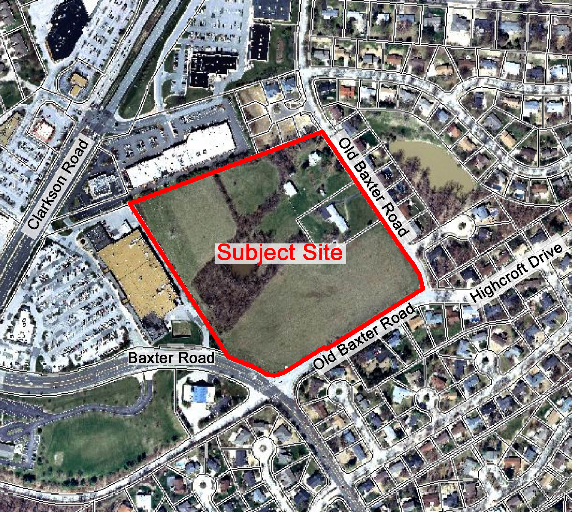
For a larger image of the site, please click here.
Anyone interested in the proceedings will be given an opportunity to be heard. Copies of the request are available for review in the Department of Planning and Public Works at Chesterfield City Hall, 690 Chesterfield Parkway West during weekdays between the hours of 8:30 a.m. and 4:30 p.m. If you should need additional information about this project, please contact Ms. Aimee Nassif, Planning and Development Services Director, by telephone at 636-537-4749 or by email at anassif@chesterfield.mo.us
FOR ADDITIONAL INFORMATION ON THIS PROJECT, PLEASE CLICK HERE.
CITY OF CHESTERFIELD
G. Elliot Grissom, Chair
Chesterfield Planning Commission
Description of Property
A tract of land in U.S. Survey 2002, Township 45 North - Range 4 East, City of Chesterfield, St. Louis County, Missouri and being more particularly described as:
Beginning at the intersection of the South line of "The Village At Olde Baxter Square," a subdivision according to the plat thereof recorded in Plat Book 355 page 378 of the St. Louis County records with the Southwest line of Old Baxter Road, varying width, as widened by instruments recorded in Book 17720 page 1437 and Book 17720 page 1442 of the St. Louis County records; thence Southeastwardly along said Southwest line of Old Baxter Road, as widened, South 34 degrees 32 minutes 32 seconds East 661.74 feet to a point; thence Northeastwardly along a Southeast line of said Old Baxter Road, varying width, as widened, North 55 degrees 27 minutes 28 seconds East 10.00 feet to a point being 15.00 feet perpendicularly distant Southwest of the original centerline; thence Southeastwardly along the Southwest line of said Old Baxter Road, varying width, South 34 degrees 32 minutes 32 seconds East 38.67 feet to the Northern most corner of a right of way dedication recorded in Book 14986 page 539 of the St. Louis County records; thence Southwardly along the West line of said right of way dedication the following courses and distances: along a curve to the right whose radius point bears South 55 degrees 27 minutes 28 seconds West 310.00 feet from the last mentioned point, a distance of 126.45 feet, South 11 degrees 10 minutes 15 seconds East 12.07 feet and along a curve to the right whose radius point bears South 78 degrees 49 minutes 45 seconds West 30.00 feet from the last mentioned point, a distance of 13.18 feet to a point in the Southeast line of U.S. Survey 2002, being also the Northwest line of said Old Baxter Road , varying width, being 15.00 feet perpendicularly distant Northwest of the original centerline; thence Southwestwardly along said Northwest line of Old Baxter Road, varying width, South 57 degrees 55 minutes 48 seconds West 499.40 feet to the Eastern most corner of a right of way dedication recorded in Book 7638 page 613 of the St. Louis County records; thence along said right of way dedication the following courses and distances: North 32 degrees 04 minutes 12 seconds West 12.50 feet, South 57 degrees 55 minutes 48 seconds West 200.64 feet and along a curve to the right whose radius point bears North 32 degrees 04 minutes 12 seconds West 119.00 feet from the last mentioned point, a distance of 129.25 feet to a point in the Southeast line of a right of way dedication recorded in Book 8147 page 437 of the St. Louis County records; thence Northeastwardly along the Southeast line of said right of way dedication North 30 degrees 09 minutes 37 seconds East 1.00 feet to a point; thence Westwardly along the North line of said right of way dedication, being also the North line of Baxter Road, varying width, along a curve to the left whose radius point bears South 30 degrees 09 minutes 37 seconds West 757.20 feet from the last mentioned point, a distance of 150.21 feet to a point in the Northeast line of property described in deed to Dierbergs Chesterfield Village, Inc. recorded in Book 8242 page 300 of the St. Louis County records; thence Northwestwardly along the Northeast line of said Dierbergs Chesterfield Village, Inc. property North 32 degrees 30 minutes 45 seconds West 815.87 feet to a point in the South line of "Drew Station Shopping Center," a subdivision according to the plat thereof recorded in Plat Book 287 page 71 of the St. Louis County records; thence Eastwardly along the South line of said "Drew Station Shopping Center" and the South line of aforesaid "The Village At Olde Baxter Square" North 68 degrees 55 minutes 54 seconds East 901.40 feet to the point of beginning and containing 18.787 acres according to a survey by Volz Incorporated.
ÂÂ