P.Z. 04-2024 The Smokehouse
NOTICE OF PUBLIC HEARING
CITY OF CHESTERFIELD
PLANNING COMMISSION
NOTICE IS HEREBY GIVEN that the Planning Commission of the City of Chesterfield will hold a Public Hearing on June 10th, 2024 at 7:00 p.m. in the Council Chambers at Chesterfield City Hall, 690 Chesterfield Parkway West, Chesterfield Missouri 63017.
Said Hearing will be as follows:
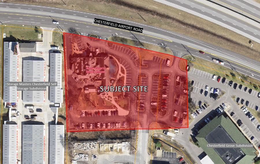
P.Z. 04-2024 The Smokehouse: A request to amend the legal description for an existing “C8” Planned Commercial District for a 2.921-acre tract of land located west of Baxter Road at Chesterfield Airport Road.
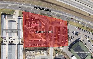
For a larger image of the site, please click HERE.
Anyone interested in the proceedings will be given an opportunity to be heard. Copies of the request are available for review in the Department of Planning at Chesterfield City Hall, 690 Chesterfield Parkway West during weekdays between the hours of 8:30 a.m. and 4:30 p.m. If you should need additional information about this project or for a list of requested uses, please contact Mr. Isaak Simmers, Planner, by telephone at 636-537-4745 or by email at isimmers@chesterfield.mo.us.
CITY OF CHESTERFIELD
Guy Tilman, Chair
Chesterfield Planning Commission
PROPERTY DESCRIPTION
A tract of land situated in the City of Chesterfield, County of St. Louis, State of Missouri, lying in part of U.S. Survey 2031, Township 45 North, Range 4 East, being those tracts of land conveyed to Thomas P. Sehnert Revocable Trust, as described in Deed Book 12593, Page 1348 and Deed Book 25268, Page 3661 of the St. Louis County Land Records, and also being that part of former Chesterfield Airport Road right-of-way conveyed to said Thomas P. Sehnert Revocable Trust by said St. Louis County, Missouri, as described in Document No. 2023072000087, and also being that part of said former Chesterfield Airport Road right-of-way conveyed to Thomas P. Sehnert Revocable Trust by said City of Chesterfield, Missouri as described in Document No. 2023072000087.
Beginning at the intersection of the Southern Line of Chesterfield Airport Road (U.S. Highway 40), 100 feet wide, with the Eastern Line of Silver Maple Farms, a Subdivision filed for record in Plat Book 274, Page 96 of the St. Louis County Land Records; thence along said Southern Line as follows: 238.25 feet along a curve to the right, with a radius of 2814.93 feet, with a central angle of 04 degrees 50 minutes 58seconds, with a chord that bears South 79 degrees 10 minutes 38 seconds East a distance of 238.18 feet to a point of a compound curve; 144.70 feet along a curve to the right, having a radius of 2,814.97 feet, through a central angle of 002 degrees 56 minutes 43 seconds, with a chord that bears South 75 degrees21 minutes 17 seconds East, a distance of 144.69 feet to a point of compound curve; 60.27 feet along a curve to the right, having a radius of 2,814.93 feet, through a central angle of 01 degrees 13 minutes 36 seconds, with a chord that bears South 73 degrees 18 minutes 00 seconds East, a distance of 60.27 feet to the intersection of said Southern Line of Chesterfield Airport Road (U.S. Highway 40), 100 feet wide with the Western Line of Chesterfield Grove Lot 1A & 3, according to Plat Book 350, Page 242 of said St. Louis County Land Records; thence leaving said Southern Line and along said Western Line, South 00degrees 45 minutes 45 seconds East, a distance of 235.19 feet; thence continuing along said Western Line and it's Westerly prolongation thereof, South 87 degrees 32 minutes 09 seconds West, a distance of180.06 feet to the Northeast corner Line of a tract of land conveyed to Neil E. Sellenriek and Mary Sellenriek Trust, as described in Deed Book 22197, Page 1063 of the St. Louis County Land Records: thence along the Northern Line of said Sellenriek Trust tract, South 87 degrees 35 minutes 59 seconds West, a distance of 243.52 feet to said Eastern Line of Silver Maple Farms; thence along said Eastern Line as follows: North 00 degrees 37 minutes 58 seconds East, a distance of 54.74 feet, North 02 degrees 21 minutes 03 seconds West, a distance of 297.25 to the point of beginning.
Containing 2.921 Acres (127,265 Square Feet), by Grimes Consulting, Inc., LS-343-D, dated April 2024