P.Z. 03-2019 Chesterfield Crossing (Chesterfield Crossing Partners, LLC)
NOTICE IS HEREBY GIVEN that the Planning Commission of the City of Chesterfield will hold a Public Hearing on Monday, March 25, 2019 at 7:00 p.m. in the Council Chambers at Chesterfield City Hall, 690 Chesterfield Parkway West, Chesterfield Missouri 63017.
Said Hearing will be as follows:
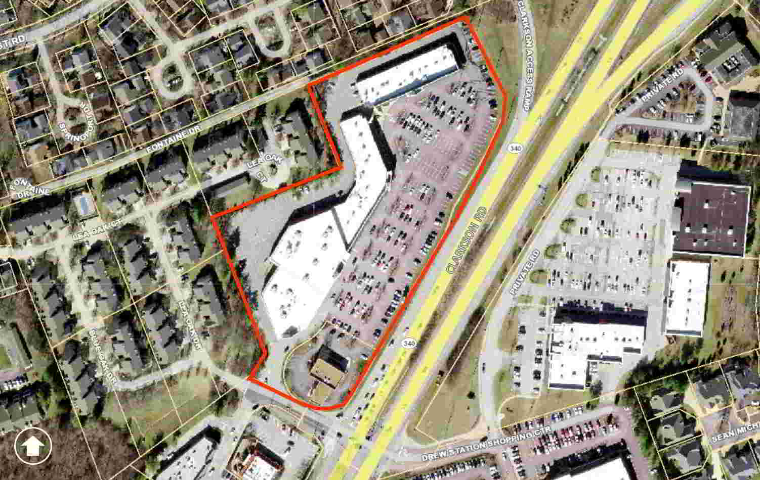
P.Z. 03-2019 Chesterfield Crossing (Chesterfield Crossing Partners, LLC): A request to amend Ordinance 1502 and repeal Ordinances 358 and 359 to establish new permitted uses and revise the development criteria for 6.9 acres of land within an existing “C-8” Planned Commercial District located at the northwest corner of the intersection of Clarkson Road and Lea Oak Drive (19S411286, 19S411275).
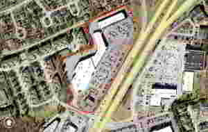
For a larger image of the site, please click HERE.
Anyone interested in the proceedings will be given an opportunity to be heard. Copies of the request are available for review in the Department of Planning & Development Services at Chesterfield City Hall, 690 Chesterfield Parkway West during weekdays between the hours of 8:30 a.m. and 4:30 p.m. If you should need additional information about this project, or for a list of requested uses, please contact Mr. Andrew Stanislav, Planner, by telephone at 636-537-4738 or by email at astanislav@chesterfield.mo.us.
CITY OF CHESTERFIELD
Merrell Hansen, Chair
Chesterfield Planning Commission
PROPERTY DESCRIPTION
A tract of land in U.S. Survey 2002, Township 45 North, Range 4 East, St. Louis County, Missouri and described as follows:
Commencing at a point in the old northwest line of Clarkson Road, 60 feet wide, said point being the most southern corner of a tract conveyed to H.G. Ungerer and wife by deed recorded in book 3502 page 552; thence north 62 degrees 47 minutes west 146.74 feet to the point of beginning; thence north 21 degrees 26 minutes 41 seconds west 169.48 feet to a point in the south line of a private road, 16 feet wide; thence along said 16 foot private road, south 67 degrees 54 minutes 24 seconds west 400.00 feet to a point; thence south 18 degrees 46 minutes 28 seconds east 200.00 feet to a point; thence south 69 degrees 59 minutes 26 seconds west 307.30 feet to a point; thence south 20 degrees 02 minutes 33 seconds east 327.68 feet to a point; thence south 37 degrees 30 minutes 34 seconds west 58.65 feet to a point; thence south 62 degrees 10 minutes 04 seconds east 213.725 feet to a point in the northwest line of Clarkson Road; thence along Clarkson Road the following courses and distances; north 64 degrees 42 minutes 50 seconds east 18.69 feet to a point, north 32 degrees 21 minutes 57 seconds east 109.180 feet to a point, north 30 degrees 30 minutes 56 seconds east 250.11 feet to a point, north 32 Degrees 25 minutes 46 seconds east 109.51 feet to a point, north 79 degrees 29 minutes 05 seconds west 23.73 feet to a point, north 39 degrees 05 minutes 26 seconds east 68.97 feet to a point, north 32 degrees 02 minutes 17 seconds east 146.58 feet to a point, north 25 degrees 57 minutes 35 seconds east 90.14 feet to a point and thence north 05 degrees 45 minutes 47 seconds west 70.45 feet to the point of beginning, and containing 6.89329 acres (300,272 square feet). Subject to easements, restrictions and conditions of record, if any.