P.Z. 14-2020 84 Lumber (17519 Chesterfield Airport Road)
NOTICE OF PUBLIC HEARING
NOTICE IS HEREBY GIVEN that the Planning Commission of the City of Chesterfield will hold a Public Hearing on Monday, January 11, 2021 at 7:00 p.m.
Due to the recommendations of the President, the Governor, and the CDC, the meeting will be conducted virtually at https://zoom.us/j/96579230947 or call in at (312) 626-6799 and enter meeting ID 965 7923 0947.
Said Hearing will be as follows:
P.Z. 14-2020 84 Lumber (17519 Chesterfield Airport Road): An ordinance amendment to modify development criteria contained in City of Chesterfield Ordinance 2575 which established a “PC” Planned Commercial District on a 7.42-acre tract of land located at 17519 Chesterfield Airport Road (17U510073).
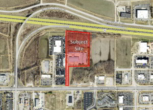
For a larger image of the site, please click HERE.
Anyone interested in the proceedings will be given an opportunity to be heard. Copies of the request are available for review in the Department of Planning at Chesterfield City Hall, 690 Chesterfield Parkway West during weekdays between the hours of 8:30 a.m. and 4:30 p.m. If you should need additional information about this project, please contact Mr. Chris Dietz, Planner, by telephone at 636-537-4745 or by email at cdietz@chesterfield.mo.us.
CITY OF CHESTERFIELD
Merrell Hansen, Chair
Chesterfield Planning Commission
PROPERTY DESCRIPTION
Lot 1 of 84 Lumber Subdivision, according to the plat thereof recorded in Plat Book 339 page 80 of the St. Louis County Records.
A tract of land being all of Lot 1 of 84 Lumber Subdivision, according to the plat thereof recorded in Plat Book 339 page 80 of the St. Louis County land records office in Clayton, Missouri being more particularly described as follows:
Beginning at a point being the northwest corner of Lot 1 of 84 Lumber Subdivision being on the southern right of way line of Interstate 64, U.S. Highway 40-61 (variable width), from which a found 1/2" iron pipe bears north 84 degrees 09 minutes 41 seconds west 0.16 feet; thence along the southern right of way line of the aforesaid interstate, south 84 degrees 06 minutes 36 seconds east a distance of 458.79 feet to a found 1/2" rebar; thence leaving said right of way line, south 00 degrees 48 minutes 46 seconds west a distance of 641.98 feet to a point from which a found 1/2" iron pipe bears north 77 degrees 19 minutes west 0.21 feet; thence south 89 degrees 35 minutes 44 seconds west a distance of 407.09 feet to a found 1/2" rebar; thence south 00 degrees 48 minutes 46 seconds west a distance of 367.38 feet to a set 1/2" x 18" rebar with cap stamped "Marler 347-d" being on the northern right of way line of Chesterfield Airport Road (100' wide); thence along the northern right of way line of Chesterfield Airport Road, south 89 degrees 35 minutes 44 seconds west a distance of 50.01 feet to a point from which a found 1/2" iron pipe bears north 85 degrees 40 minutes west a distance of 0.61 feet; thence leaving said right of way, north 00 degrees 48 minutes 46 seconds east a distance of 1059.68 feet to the point of beginning containing 323,240 sq. ft. or 7.42 acres more or less as surveyed by Marler Surveying Company Inc. during September 2019.