P.Z. 19-2017 Downtown Chesterfield (Sachs Properties)
NOTICE OF PUBLIC HEARING
CITY OF CHESTERFIELD
PLANNING COMMISSION
NOTICE IS HEREBY GIVEN that the Planning Commission of the City of Chesterfield will hold a Public Hearing on Monday, December 11, 2017 at 7:00 p.m. in the Council Chambers at Chesterfield City Hall, 690 Chesterfield Parkway West, Chesterfield Missouri 63017.
Said Hearing will be as follows:
P.Z. 19-2017 Downtown Chesterfield (Sachs Properties): A request to amend the legal description and preliminary plan of existing “PC&R” Planned Commercial & Residential Ordinance 2449 for a 104.9 acre tract of land located at the southwest corner of the intersection of U.S. Highway 40/I-64 and Chesterfield Parkway West.
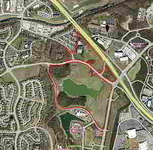
For a larger image of the site, please click HERE.
Anyone interested in the proceedings will be given an opportunity to be heard. Copies of the request are available for review in the Department of Planning & Development Services at Chesterfield City Hall, 690 Chesterfield Parkway West during weekdays between the hours of 8:30 a.m. and 4:30 p.m. If you should need additional information about this project, or for a list of requested uses, please contact Ms. Cecilia Dvorak, Project Planner, by telephone at 636-537-4738 or by email at cdvorak@chesterfield.mo.us
CITY OF CHESTERFIELD
Merrell Hansen, Chair
Chesterfield Planning Commission
PROPERTY DESCRIPTION
AREA 1
A tract of land being part of U.S. Surveys 123, 415 and 2031 and part of Lot C120 of “Chesterfield Village Area A Phase One Plat Two” in Township 45 North – Range 4 East, City of Chesterfield, St. Louis County, Missouri and being more particularly described as follows:
Beginning at the Southwest corner of property described in the deed to Chesterfield Village, Inc. recorded in Book 6881 page 1745 of the St. Louis County Records; thence Northwardly along the West line of said Chesterfield Village, Inc. property being also the East line of property described in the deed to Richard B. Godwin recorded in Book 12444 page 731 of the St. Louis County Records North 00 degrees 02 minutes 30 seconds East 307.86 feet to a point on the South line of Relocated Wildhorse Creek Road of varying width as shown on the “Wild Horse Creek Road Dedication Plat” recorded in Plat Book 354 pages 865 and 866 of the St. Louis County Records; thence Eastwardly along said South line the following courses and distances: along a curve to the left, whose radius point bears North 19 degrees 51 minutes 11 seconds West 991.00 feet from the last mentioned point, a distance of 19.25 feet, North 79 degrees 48 minutes 05 seconds East 84.71 feet, along a curve to the right, whose radius point bears South 15 degrees 42 minutes 05 seconds East 907.00 feet from the last mentioned point, a distance of 320.45 feet, North 04 degrees 32 minutes 30 seconds East 12.00 feet, along a curve to the right, whose radius point bears South 04 degrees 32 minutes 30 seconds West 919.00 feet from the last mentioned point, a distance of 623.36 feet to a point on the West line of property described in the deed to Chesterfield Airport Road Group Partnership recorded in Book 8296 page 1439 of the St. Louis County Records; thence Southwardly along said West line South 00 degrees 38 minutes 59 seconds West 323.47 feet to a point; thence North 45 degrees 14 minutes 46 seconds East 232.33 feet to a point on the Southwest line of Chesterfield Airport Road of varying width; thence along the right-of-way line of Chesterfield Airport Road the following courses and distances: along a curve to the left, whose radius point bears North 41 degrees 26 minutes 45 seconds East 1181.92 feet from the last mentioned point, a distance of 25.00 feet, South 49 degrees 45 minutes 58 seconds East 4.14 feet, South 44 degrees 11 minutes 16 seconds East 3.70 feet, South 49 seconds 40 minutes 42 seconds East 36.63 feet, South 40 degrees 19 minutes 18 seconds West 20.00 feet, South 49 degrees 40 minutes 42 seconds East 112.45 feet, along a curve to the left, whose radius point bears North 40 degrees 19 minutes 18 seconds East 1959.86 feet from the last mentioned point, a distance of 301.05 feet, South 58 degrees 28 minutes 42 seconds East 163.68 feet, along a curve to the left, whose radius point bears North 31 degrees 31 minutes 18 seconds East 1959.86 feet from the last mentioned point, a distance of 84.78 feet and South 17 degrees 45 minutes 50 seconds East 135.94 feet to a point on the West line of Chesterfield Village Parkway 73 feet wide; thence Southwardly along said West line along a curve to the left, whose radius point bears South 65 degrees 36 minutes 56 seconds East 1186.50 feet from the last mentioned point, a distance of 296.65 feet, South 10 degrees 03 minutes 33 seconds West 1252.38 feet and South 55 degrees 03 minutes 33 seconds West 35.36 feet to a point on the right-of-way of Burkhardt Place; thence along the right-of-way of Burkhardt Place the following courses and distances: North 79 degrees 56 minutes 27 seconds West 15.00 feet, South 10 degrees 03 minutes 33 seconds West 4.00 feet, along a curve to the right, whose radius point bears North 10 degrees 04 minutes 13 seconds East 289.23 feet from the last mentioned point, a distance of 244.78 feet, North 31 degrees 26 minutes 20 seconds West 472.64 feet and along a curve to the left, whose radius point bears South 58 degrees 33 minutes 40 seconds West 568.00 feet from the last mentioned point, a distance of 351.80 feet, along a curve to the left, whose radius point bears South 23 degrees 04 minutes 25 seconds West 818.00 feet from the last mentioned point, a distance of 281.27 feet to a point; thence North 03 degrees 22 minutes 22 seconds East 8.50 feet to a point; thence along a curve to the left, whose radius point bears South 03 degrees 22 minutes 22 seconds West 826.50 feet from the last mentioned point, a distance of 244.40 feet to a point; thence South 76 degrees 25 minutes 47 seconds West 99.72 feet to a point; thence along a curve to the right, whose radius point bears North 13 degrees 34 minutes 13 seconds West 345.00 feet from the last mentioned point, a distance of 697.80 feet to a point; thence along a curve to the left, whose radius point bears North 77 degrees 41 minutes 01 seconds West 985.00 feet from the last mentioned point, a distance of 900.59 feet to a point; thence along a curve to the right, whose radius point bears North 49 degrees 55 minutes 50 seconds East 345.00 feet from the last mentioned point, a distance of 294.85 feet to a point; thence North 08 degrees 53 minutes 55 seconds East 9.88 feet to a point; thence along a curve to the right, whose radius point bears South 81 degrees 06 minutes 05 seconds East 84.61 feet from the last mentioned point, a distance of 89.04 feet to a point; on the West line of aforesaid Godwin property; thence Southwardly along said West line South 06 degrees 56 minutes 30 seconds West 255.38 feet to a point; thence South 89 degrees 53 minutes 36 seconds East 583.09 feet to the point of beginning and containing 74.36 acres according to calculations by Volz Inc. during December 2006.
AREA 2
A tract of land in U.S. Surveys 123 and 2031, Township 45 North – Range 4 East, in the City of Chesterfield, St. Louis County, Missouri and being more particularly described as follows:
Beginning at the intersection of the West line of property of Chesterfield Village, Inc., as described in the deed recorded in Book 6881 page 1745 of the St. Louis County Records with the North line of Relocated Wild Horse Creek Road, as shown on the “Wild Horse Creek Road Dedication Plat” recorded in Plat Book 354 pages 865 and 866 of the St. Louis County Records; thence Northwardly along said East line North 00 degrees 02 minutes 30 seconds East 551.26 feet to a point on the Southwest line of Chesterfield Airport Road (formerly Olive Street Road); thence South 57 degrees 18 minutes 34 seconds East 191.41 feet to a point; thence South 55 degrees 38 minutes 57 seconds East 90.12 feet to a point; thence along a curve to the left, whose radius point bears South 59 degrees 01 minutes 58 seconds West 602.96 feet from the last mentioned point, a distance of 85.20 feet to a point on the centerline of said Chesterfield Airport Road; thence along said centerline South 55 degrees 38 minutes 57 seconds East 312.75 feet to a point on the West line of U.S. Survey 123; thence Northwardly along said West line North 00 degrees 05 minutes 18 seconds East 888.55 feet to a point on the Southwest right of way line of Missouri Interstate Highway 64 (State Highway Route 40 T.R.) of varying width; thence South 42 degrees 03 minutes 01 seconds East 271.15 feet to a point; thence South 42 degrees 13 minutes 47 seconds East 477.80 feet to a point; thence South 40 degrees 02 minutes 17 seconds East 336.56 feet to a point; thence South 37 degrees 12 minutes 27 seconds East 198.40 feet to a point; thence South 35 degrees 44 minutes 14 seconds East 128.95 feet to a point; thence South 76 degrees 41 minutes 55 seconds West 16.52 feet to a point; thence South 34 degrees 43 minutes 14 seconds East 34.68 feet to a point; thence South 24 degrees 25 minutes 24 seconds East 129.32 feet to a point; thence South 14 degrees 28 minutes 56 seconds West 134.14 feet to a point; thence South 03 degrees 22 minutes 08 seconds East 145.49 feet to a point; thence South 40 degrees 19 minutes 00 seconds West 105.00 feet to a point; thence South 87 degrees 48 minutes 22 seconds West 81.39 feet to a point; thence South 40 degrees 19 minutes 00 seconds West 20.00 feet to a point; thence North 49 degrees 40 minutes 43 seconds West 33.82 feet to a point; thence North 44 degrees 11 minutes 16 seconds West 327.23 feet to a point; thence along a curve to the left, whose radius point bears South 39 degrees 30 minutes 15 seconds West 991.00 feet from the last mentioned point, a distance of 118.97 feet to a point; thence North 77 degrees 09 minutes 59 seconds East 51.40 feet to a point on the North line of property of Chesterfield Village, Inc. as described in the deed recorded in Book 14336 page 2705 of the St. Louis County Records; thence Eastwardly along said North line North 61 degrees 01 minutes 19 seconds East 68.88 feet, North 62 degrees 47 minutes 13 seconds East 24.33 feet, North 75 degrees 05 minutes 24 seconds East 59.17 feet and North 67 degrees 06 minutes 31 seconds East 26.83 feet to a point on the East line of property of Theodore J. Loeffler and wife as described in the deed recorded in Book 6672 page 1193 of the St. Louis County Records; thence Northwardly along said East line North 06 degrees 30 minutes 29 seconds West 53.70 feet to a point; thence South 77 degrees 09 minutes 59 seconds West 296.16 feet to a point on the centerline of aforesaid Wildhorse Creek Road; thence along said centerline South 44 degrees 11 minutes 16 seconds East 67.40 feet to a point; thence along a curve to the left, whose radius point bears South 30 degrees 19 minutes 17 seconds West 991.00 feet from the last mentioned point, a distance of 878.76 feet to the point of beginning and containing 20.83 acres according to calculations by Volz Inc. during December 2006.
AND
A tract of land being part of U.S. Survey 2031 in Township 45 North - Range 4 East, City of Chesterfield, St. Louis County, Missouri and being more particularly described as follows:
Beginning at the Southwest corner of property described in the deed to Chesterfield Village, Inc. recorded in Book 6881 page 1745 of the St. Louis County Records, aforesaid Southwest corner being on the South line of aforesaid of U.S. Survey 2031; thence Westward along aforesaid U.S. Survey line being also the South line of property described in the deed to Richard B. Godwin recorded in Book 12444 page 731 of the St. Louis County Records North 89 degrees 53 minutes 36 seconds West 583.09 feet to the Southwest corner of aforesaid Godwin property; thence Northwardly along the West line of aforesaid Godwin property North 06 degrees 56 minutes 30 seconds East 268.18 feet to a point on the South line of Relocated Wildhorse Creek Road of varying width as shown on the "Wild Horse Creek Road Dedication Plat" recorded in Plat Book 354 pages 865 and 866 of the St. Louis County Records; thence Eastwardly along aforesaid South line along a curve to the left, whose radius point bears North 12 degrees 25 minutes 44 seconds East 996.00 feet from the last mentioned point, a distance of 559.36 feet; thence Southwardly along aforesaid West line of the Chesterfield Village, Inc. property being also the East line of aforesaid Godwin property South 00 degrees 02 minutes 30 seconds West 302.54 feet to the point of beginning and containing 3.364 acres according to calculations by Grimes Consulting, Inc. during October 2017.
AREA 3
A tract of land in U.S. Survey 123, Township 45 North – Range 4 East, St. Louis County, Missouri and being more particularly described as:
Beginning at a point on the Southwest right-of-way line of U.S. Highway 40, said point being distant North 33 degrees 47 minutes 31 seconds West 41.56 feet from the South line of said U.S. Survey 123, said point also being perpendicular distant North 53 degrees 04 minutes 08 seconds West 85.00 feet from the centerline of Chesterfield Parkway; thence Southwestwardly along the Northwest right-of-way line of said Chesterfield Parkway South 36 degrees 55 minutes 52 seconds West 59.27 feet to the said South line of U.S. Survey 123; thence West along said South line of U.S. Survey 123 South 77 degrees 39 minutes 53 seconds West 110.86 feet to the North right-of-way line of Chesterfield Airport Road, 100 feet wide; thence Westwardly along said North right-of-way line of Chesterfield Airport Road, 100 feet wide, along a curve to the right, whose radius point bears North 29 degrees 47 minutes 51 seconds East 1859.86 feet from the last mentioned point, a distance of 55.96 feet, North 58 degrees 28 minutes 42 seconds West 163.68 feet and along a curve to the right, whose radius point bears North 31 degrees 31 minutes 18 seconds East 1859.86 feet from the last mentioned point, a distance of 117.66 feet to the limited access line of Ramp “A”; thence along the said limited access line of Ramp “A” the following courses and distances: North 18 degrees 05 minutes 04 seconds West 139.51 feet, North 38 degrees 44 minutes 47 seconds East 50.00 feet and North 29 degrees 35 minutes 23 seconds East 237.00 feet to the aforesaid Southwest right-of-way line of U.S. Highway 40; thence Southeastwardly along said Southwest right-of-way line of U.S. Highway 40 South 33 degrees 47 minutes 31 seconds East 584.07 feet to the point of beginning and containing 2.91 acres.