P.Z. 14-2013 St. Luke’s Hospital-West Campus (175 S. Woods Mill Rd.):
NOTICE OF PUBLIC HEARING
CITY OF CHESTERFIELD
PLANNING COMMISSION
NOTICE IS HEREBY GIVEN that the Planning Commission of the City of Chesterfield will hold a Public Hearing on December 9, 2013 at 7:00 p.m. in the City Council Chambers at Chesterfield City Hall, 690 Chesterfield Parkway West, Chesterfield, Missouri 63017. Said Hearing will be as follows:
P.Z. 14-2013 St. Luke’s Hospital-West Campus (175 S. Woods Mill Rd.): A request for a zoning map amendment from “MU” Medical Use District, “R-2” Residence District and “FPNU” Flood Plain Non-Urban District to create a new “MU” Medical Use District for a 40.3 acre tract of land located west of the intersection of South Woods Mill Road and Hwy 141 (18Q140343, 18Q510278, 18Q230204 and 18Q210211).
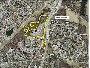
For a larger image of the site, please click HERE.
For a list of the requested uses, contact the project planner.
Anyone interested in the proceedings will be given an opportunity to be heard. Copies of the request, as well as the requested uses, are available for review from the Planning and Development Services Division at Chesterfield City Hall, 690 Chesterfield Parkway West, weekdays between the hours of 8:30 a.m. and 4:30 p.m. If you should need additional information about this project, please contact John Boyer, Senior Planner by telephone at 636-537-4734 or by email at jboyer@chesterfield.mo.us.
CITY OF CHESTERFIELD
Michael Watson, Chair
Chesterfield Planning Commission
Description of Property
PARCELS B & D
A tract of land being part of the Lot Consolidation Plat “St. Luke’s Hospital Northwest” as recorded in Plat Book 356, Page 681-682 of the St. Louis County, Missouri Recorder’s Office and a tract of land conveyed to St. Luke’s Episcopal Presbyterian Hospitals by a deed recorded in Deed Book 20022, Page 178 of the aforesaid Recorder’s Office, and a tract being the same property as described in deeds to St. Luke’s Episcopal Presbyterian Hospital as recorded in Deed Book 6333, Page 864 and Deed Book 15025, Page 1262 of the St. Louis County, Missouri Recorder’s Office and being part of US Survey 109 in Township 45 North, Range 4 and 5 East of the Fifth Principal Meridian, City of Chesterfield, St. Louis County, Missouri. BEGINNING at the intersection of the Southern line “St. Luke’s Hospital Northwest” a subdivision recorded in Plat Book 356, Pages 681 – 682 of the St. Louis County, Missouri Recorder’s Office with the Western line of a tract of land conveyed to the City of Chesterfield as recorded in Deed Book 17979, Page 5300 of the aforesaid Recorder’s Office; thence along the Southern line of St. Luke’s Hospital Northwest” the following: North 74 degrees 49 minutes 15 seconds West, a distance of 151.72 feet to a point; thence North 77 degrees 48 minutes 14 seconds West, a distance of 99.92 feet to a point; thence North 85 degrees 55 minutes 43 seconds West, a distance of 99.92 feet to a point; thence South 80 degrees 56 minutes 14 seconds West, a distance of 100.04 feet to a point; thence South 73 degrees 57 minutes 55 seconds West, a distance of 100.07 feet to a point; thence North 74 degrees 46 minutes 35 seconds West, a distance of 765.52 feet to the Western line of said “St. Luke’s Hospital Northwest”; thence along said Western line the following: North 08 degrees 53 minutes 43 seconds East, a distance of 115.49 feet to a point; thence North 46 degrees 44 minutes 38 seconds East, a distance of 205.29 feet to a point; thence South 76 degrees 22 minutes 26 seconds East, a distance of 12.67 feet to a point; thence North 21 degrees 28 minutes 00 seconds East, a distance of 97.00 feet to a point; thence North 28 degrees 58 minutes 00 seconds West, a distance of 86.20 feet to a point; thence North 81 degrees 31 minutes 00 seconds West, a distance of 99.00 feet to a point; thence South 61 degrees 27 minutes 00 seconds West, a distance of 127.50 feet to a point; thence North 13 degrees 20 minutes 00 seconds West, a distance of 366.78 feet to a point; thence North 85 degrees 54 minutes 00 seconds East, a distance of 41.00 feet to a point; thence South 64 degrees 50 minutes 00 seconds East, a distance of 76.68 feet to a point; thence South 83 degrees 59 minutes 00 seconds East, a distance of 70.00 feet to a point; thence South 48 degrees 04 minutes 00 seconds East, a distance of 48.00 feet to a point; thence South 30 degrees 11 minutes 00 seconds East, a distance of 62.00 feet to a point; thence South 64 degrees 57 minutes 00 seconds East, a distance of 38.00 feet to a point; thence North 65 degrees 11 minutes 00 seconds East, a distance of 60.00 feet to a point; thence North 42 degrees 39 minutes 00 seconds East, a distance of 46.00 feet to a point; thence South 45 degrees 54 minutes 00 seconds East, a distance of 80.00 feet to a point; thence South 00 degrees 50 minutes 00 seconds West, a distance of 192.17 feet to a point; thence South 46 degrees 45 minutes 00 seconds East, a distance of 99.00 feet to a point; thence North 67 degrees 23 minutes 00 seconds East, a distance of 306.05 feet to a point; thence South 71 degrees 42 minutes 00 seconds East, a distance of 116.65 feet to a point; thence North 75 degrees 00 minutes 00 seconds East, a distance of 94.80 feet to a point; thence North 16 degrees 57 minutes 37 seconds East, a distance of 315.29 feet to a point; thence North 81 degrees 22 minutes 26 seconds West, a distance of 73.02 feet to a point; thence North 85 degrees 37 minutes 26 seconds West, a distance of 125.00 feet to a point; thence along a curve having a radius of 100.00 feet, an arc length of 136.99 feet, and a chord which bears South 54 degrees 07 minutes 56 seconds West, a chord distance of 126.53 feet to a point; thence along a curve having a radius of 125.00 feet, an arc length of 105.00 feet, and a chord which bears South 41 degrees 59 minutes 32 seconds West, a chord distance of 101.94 feet to a point; thence along a curve having a radius of 200.00 feet, an arc length of 189.99 feet, and a chord which bears North 50 degrees 59 minutes 36 seconds West, a chord distance of 182.93 feet to a point; thence along a curve having a radius of 400.00 feet, an arc length of 190.00 feet, and a chord which bears North 13 degrees 23 minutes 32 seconds East, a chord distance of 188.22 feet to a point; thence along a curve having a radius of 125.00 feet, an arc length of 88.00 feet, and a chord which bears North 42 degrees 49 minutes 28 seconds East, a chord distance of 86.19 feet to a point; thence along a curve having a radius of 400.00 feet, an arc length of 170.00 feet, and a chord which bears South 85 degrees 56 minutes 08 seconds East, a chord distance of 168.72 feet to a point; thence South 78 degrees 57 minutes 26 seconds East, a distance of 125.00 feet to a point; thence North 78 degrees 37 minutes 34 seconds East, a distance of 82.50 feet to a point; thence South 84 degrees 07 minutes 26 seconds East, a distance of 37.00 feet to a point; thence North 76 degrees 37 minutes 34 seconds East, a distance of 130.00 feet to a point; thence along a curve having a radius of 100.00 feet, an arc length of 80.01 feet, and a chord which bears North 36 degrees 28 minutes 15 seconds East, a chord distance of 77.89 feet to a point; thence North 21 degrees 34 minutes 56 seconds East, a distance of 74.43 feet to a point; thence North 09 degrees 43 minutes 36 seconds East, a distance of 106.30 feet to a point; thence North 04 degrees 08 minutes 47 seconds West, a distance of 85.59 feet to the Northern line of said “St. Luke’s Hospital Northwest”; thence along said Northern line South 83 degrees 25 minutes 35 seconds East, a distance of 29.90 feet to the intersection with the Western line of a tract of land conveyed to St. Luke’s Episcopal Presbyterian Hospital by a deed recorded in Deed Book 20022, page 178 of the aforesaid Recorder’s Office; thence along said Western line North 03 degrees 52 minutes 16 seconds East, a distance of 98.06 feet to a point; thence North 13 degrees 15 minutes 33 seconds East, a distance of 31.73 feet to a point; thence North 18 degrees 35 minutes 59 seconds East, a distance of 17.37 feet to a point; thence North 23 degrees 29 minutes 12 seconds East, a distance of 22.10 feet to a point; thence North 10 degrees 55 minutes 27 seconds East, a distance of 18.51 feet to a point; thence North 19 degrees 54 minutes 41 seconds East, a distance of 34.19 feet to a point; thence North 69 degrees 48 minutes 43 seconds East, a distance of 42.69 feet to the Northern line of said tract; thence along said Northern line South 83 degrees 25 minutes 36 seconds East, a distance of 576.73 feet to the Western right-of-way of Missouri State Highway 141; thence along said Western right-of-way the following: South 29 degrees 54 minutes 18 seconds West, a distance of 36.74 feet to a point; thence South 16 degrees 45 minutes 18 seconds West, a distance of 154.04 feet to a point; thence South 29 degrees 42 minutes 12 seconds West, a distance of 57.84 feet to a point; thence South 24 degrees 46 minutes 16 seconds West, a distance of 253.05 feet to a point; thence along a curve to the left having a radius of 1549.94 feet, an arc length of 304.68 feet, and a chord which bears South 13 degrees 02 minutes 49 seconds West, a chord distance of 304.19 feet to a point; thence South 08 degrees 10 minutes 33 seconds West, a distance of 12.96 feet to a point; thence South 07 degrees 37 minutes 43 seconds West, a distance of 220.03 feet to a point; thence South 07 degrees 37 minutes 40 seconds West, a distance of 425.18 feet to the Northernmost corner of a tract of land described in a deed to the City of Chesterfield as recorded in Deed Book 17979, Page 5300 of the aforesaid St. Louis County Recorder’s Office; thence along the Western line of said tract along a curve to the right having a radius of 345.00 feet, an arc length of 120.79 feet, and a chord which bears South 37 degrees 11 minutes 29 seconds West, a chord distance of 120.18 feet to a point; thence along a curve to the left having a radius of 405.00 feet, an arc length of 182.37 feet, and a chord which bears South 34 degrees 19 minutes 18 seconds West, a chord distance of 180.83 feet to a point; thence South 81 degrees 29 minutes 29 seconds West, a distance of 34.94 feet to a point; thence South 16 degrees 14 minutes 55 seconds West, a distance of 30.00 feet to the Point of Beginning and containing 1,659,761 square feet or 38.102 acres more or less as per calculations by Stock & Associates Consulting Engineers, Inc. during August, 2013. PART OF ORGINAL PARCEL B A tract of land being part of the Lot Consolidation Plat “St. Luke’s Hospital Northwest” as recorded in Plat Book 356, Page 681-682 of the St. Louis County, Missouri Recorder’s Office and being part of US Survey 109 and Part of Section 7 in Township 45 North, Range 4 and 5 East of the Fifth Principal Meridian, City of Chesterfield, St. Louis County, Missouri and being more particularly described as follows: COMMENCING at the Southeastern corner of a tract of land described in a deed to the City of Chesterfield as recorded in Deed Book 17979, Page 5300 of the St. Louis County, Missouri Recorder’s Office; thence along the Eastern line of said tract in a Northerly direction along a curve to the left having a radius of 2033.68 feet, an arc length of 16.72 feet, the chord of which bears North 08 degrees 23 minutes 03 seconds East a chord distance of 19.72 feet to the POINT OF BEGINNING of the tract herein described; thence continuing along said Eastern line the following: in a Northwesterly direction along a curve to the left having a radius of 235.00 feet, an arc length of 43.68 feet, and a chord which bears North 63 degrees 13 minutes 38 seconds West, a chord distance of 43.62 feet to a point; thence along a curve to the right having a radius of 39.00 feet, an arc length of 65.11 feet, and a chord which bears North 20 degrees 43 minutes 20 seconds West, a chord distance of 57.81 feet to a point; thence along a curve to the right having a radius of 270.00 feet, an arc length of 34.09 feet, and a chord which bears North 30 degrees 43 minutes 27 seconds East, a chord distance of 34.07 feet to a point; thence along a curve to the right having a radius of 345.00 feet, an arc length of 77.56 feet, and a chord which bears North 40 degrees 46 minutes 53 seconds East, a chord distance of 77.40 feet to a point; thence along a curve to the left having a radius of 405.00 feet, an arc length of 21.17 feet, and a chord which bears North 45 degrees 43 minutes 28 seconds East, a chord distance of 21.16 feet to the Western right-of-way line of Missouri State Highway 141; thence along said right-of-way line South 07 degrees 37 minutes 40 seconds West, a distance of 159.48 feet to a point; thence along a curve to the right having a radius of 2033.68 feet, an arc length of 18.49 feet, and a chord which bears South 07 degrees 53 minutes 18 seconds West, a chord distance of 18.49 feet to a point; thence North 81 degrees 51 minutes 05 seconds West, a distance of 0.01 feet to the Point of Beginning and containing 7,971 square feet or 0.183 acres more or less as per calculations by Stock & Associates Consulting Engineers, Inc. during August, 2013. PARCEL C A tract of land being the same property as described in deeds to St. Luke’s Episcopal Presbyterian Hospital as recorded in Deed Book 6333, Page 864 and Deed Book 15025, Page 1262 of the St. Louis County, Missouri Recorder’s Office, and being part of US Survey 109 in Township 45 North, Rang 4 and 5 East of the Fifth Principal Meridian, City of Chesterfield, St. Louis County, Missouri and being more particularly described as follows: BEGINNING at the Southeast corner of a the tract of land described in Deed Book15025, Page 1262 of the St. Louis County, Missouri Recorder’s Office; thence along the Southern line of said tract North 62 degrees 54 minutes 44 seconds West, a distance of 230.36 feet to the Eastern line of South Woods Mill Road; thence along said Eastern line in a Northerly direction a curve to the left having a radius of 2133.68 feet, an arc length of 307.77 feet, and a chord which bears North 23 degrees 51 minutes 35 seconds East, a chord distance of 307.50 feet to a point; thence along a curve to the left having a radius of 2133.68 feet, an arc length of 234.73 feet, and a chord which bears North 16 degrees 34 minutes 33 seconds East, a chord distance of 234.61 feet to the Southern line of Brookings Park; thence along said Southern line South 82 degrees 43 minutes 11 seconds East, a distance of 1.23 feet to a point; thence along a curve to the left having a radius of 211.00 feet, an arc length of 79.84 feet, and a chord which bears South 66 degrees 37 minutes 00 seconds East, a chord distance of 79.36 feet to a point; thence South 32 degrees 45 minutes 20 seconds East, a distance of 30.07 feet to a point on the Western right-of-way line of Missouri State Highway 141; thence along said Western right-of-way line the following: South 00 degrees 53 minutes 53 seconds West, a distance of 138.27 feet to a point; thence South 03 degrees 01 minutes 09 seconds West, a distance of 60.33 feet to a point; thence South 14 degrees 44 minutes 00 seconds West, a distance of 187.46 feet to a point; thence along a curve having a radius of 3697.72 feet, an arc length of 175.85 feet, and a chord which bears South 07 degrees 41 minutes 42 seconds West, a chord distance of 175.83 feet to a point; thence North 09 degrees 02 minutes 59 seconds East, a distance of 0.00 feet to the Point of Beginning and containing 87,790 square feet or 2.015 acres more or less as per calculations by Stock & Associates Consulting Engineers, Inc. during August, 2013.
P.Z. 14-2013 St. Luke’s Hospital-West Campus (175 S. Woods Mill Rd.): A request for a zoning map amendment from “MU” Medical Use District, “R-2” Residence District and “FPNU” Flood Plain Non-Urban District to create a new “MU” Medical Use District for a 40.3 acre tract of land located west of the intersection of South Woods Mill Road and Hwy 141 (18Q140343, 18Q510278, 18Q230204 and 18Q210211).
For a larger image of the site, please click HERE.
For a list of the requested uses, contact the project planner.
Anyone interested in the proceedings will be given an opportunity to be heard. Copies of the request, as well as the requested uses, are available for review from the Planning and Development Services Division at Chesterfield City Hall, 690 Chesterfield Parkway West, weekdays between the hours of 8:30 a.m. and 4:30 p.m. If you should need additional information about this project, please contact John Boyer, Senior Planner by telephone at 636-537-4734 or by email at jboyer@chesterfield.mo.us.
CITY OF CHESTERFIELD
Michael Watson, Chair
Chesterfield Planning Commission
Description of Property
PARCELS B & D
A tract of land being part of the Lot Consolidation Plat “St. Luke’s Hospital Northwest” as recorded in Plat Book 356, Page 681-682 of the St. Louis County, Missouri Recorder’s Office and a tract of land conveyed to St. Luke’s Episcopal Presbyterian Hospitals by a deed recorded in Deed Book 20022, Page 178 of the aforesaid Recorder’s Office, and a tract being the same property as described in deeds to St. Luke’s Episcopal Presbyterian Hospital as recorded in Deed Book 6333, Page 864 and Deed Book 15025, Page 1262 of the St. Louis County, Missouri Recorder’s Office and being part of US Survey 109 in Township 45 North, Range 4 and 5 East of the Fifth Principal Meridian, City of Chesterfield, St. Louis County, Missouri. BEGINNING at the intersection of the Southern line “St. Luke’s Hospital Northwest” a subdivision recorded in Plat Book 356, Pages 681 – 682 of the St. Louis County, Missouri Recorder’s Office with the Western line of a tract of land conveyed to the City of Chesterfield as recorded in Deed Book 17979, Page 5300 of the aforesaid Recorder’s Office; thence along the Southern line of St. Luke’s Hospital Northwest” the following: North 74 degrees 49 minutes 15 seconds West, a distance of 151.72 feet to a point; thence North 77 degrees 48 minutes 14 seconds West, a distance of 99.92 feet to a point; thence North 85 degrees 55 minutes 43 seconds West, a distance of 99.92 feet to a point; thence South 80 degrees 56 minutes 14 seconds West, a distance of 100.04 feet to a point; thence South 73 degrees 57 minutes 55 seconds West, a distance of 100.07 feet to a point; thence North 74 degrees 46 minutes 35 seconds West, a distance of 765.52 feet to the Western line of said “St. Luke’s Hospital Northwest”; thence along said Western line the following: North 08 degrees 53 minutes 43 seconds East, a distance of 115.49 feet to a point; thence North 46 degrees 44 minutes 38 seconds East, a distance of 205.29 feet to a point; thence South 76 degrees 22 minutes 26 seconds East, a distance of 12.67 feet to a point; thence North 21 degrees 28 minutes 00 seconds East, a distance of 97.00 feet to a point; thence North 28 degrees 58 minutes 00 seconds West, a distance of 86.20 feet to a point; thence North 81 degrees 31 minutes 00 seconds West, a distance of 99.00 feet to a point; thence South 61 degrees 27 minutes 00 seconds West, a distance of 127.50 feet to a point; thence North 13 degrees 20 minutes 00 seconds West, a distance of 366.78 feet to a point; thence North 85 degrees 54 minutes 00 seconds East, a distance of 41.00 feet to a point; thence South 64 degrees 50 minutes 00 seconds East, a distance of 76.68 feet to a point; thence South 83 degrees 59 minutes 00 seconds East, a distance of 70.00 feet to a point; thence South 48 degrees 04 minutes 00 seconds East, a distance of 48.00 feet to a point; thence South 30 degrees 11 minutes 00 seconds East, a distance of 62.00 feet to a point; thence South 64 degrees 57 minutes 00 seconds East, a distance of 38.00 feet to a point; thence North 65 degrees 11 minutes 00 seconds East, a distance of 60.00 feet to a point; thence North 42 degrees 39 minutes 00 seconds East, a distance of 46.00 feet to a point; thence South 45 degrees 54 minutes 00 seconds East, a distance of 80.00 feet to a point; thence South 00 degrees 50 minutes 00 seconds West, a distance of 192.17 feet to a point; thence South 46 degrees 45 minutes 00 seconds East, a distance of 99.00 feet to a point; thence North 67 degrees 23 minutes 00 seconds East, a distance of 306.05 feet to a point; thence South 71 degrees 42 minutes 00 seconds East, a distance of 116.65 feet to a point; thence North 75 degrees 00 minutes 00 seconds East, a distance of 94.80 feet to a point; thence North 16 degrees 57 minutes 37 seconds East, a distance of 315.29 feet to a point; thence North 81 degrees 22 minutes 26 seconds West, a distance of 73.02 feet to a point; thence North 85 degrees 37 minutes 26 seconds West, a distance of 125.00 feet to a point; thence along a curve having a radius of 100.00 feet, an arc length of 136.99 feet, and a chord which bears South 54 degrees 07 minutes 56 seconds West, a chord distance of 126.53 feet to a point; thence along a curve having a radius of 125.00 feet, an arc length of 105.00 feet, and a chord which bears South 41 degrees 59 minutes 32 seconds West, a chord distance of 101.94 feet to a point; thence along a curve having a radius of 200.00 feet, an arc length of 189.99 feet, and a chord which bears North 50 degrees 59 minutes 36 seconds West, a chord distance of 182.93 feet to a point; thence along a curve having a radius of 400.00 feet, an arc length of 190.00 feet, and a chord which bears North 13 degrees 23 minutes 32 seconds East, a chord distance of 188.22 feet to a point; thence along a curve having a radius of 125.00 feet, an arc length of 88.00 feet, and a chord which bears North 42 degrees 49 minutes 28 seconds East, a chord distance of 86.19 feet to a point; thence along a curve having a radius of 400.00 feet, an arc length of 170.00 feet, and a chord which bears South 85 degrees 56 minutes 08 seconds East, a chord distance of 168.72 feet to a point; thence South 78 degrees 57 minutes 26 seconds East, a distance of 125.00 feet to a point; thence North 78 degrees 37 minutes 34 seconds East, a distance of 82.50 feet to a point; thence South 84 degrees 07 minutes 26 seconds East, a distance of 37.00 feet to a point; thence North 76 degrees 37 minutes 34 seconds East, a distance of 130.00 feet to a point; thence along a curve having a radius of 100.00 feet, an arc length of 80.01 feet, and a chord which bears North 36 degrees 28 minutes 15 seconds East, a chord distance of 77.89 feet to a point; thence North 21 degrees 34 minutes 56 seconds East, a distance of 74.43 feet to a point; thence North 09 degrees 43 minutes 36 seconds East, a distance of 106.30 feet to a point; thence North 04 degrees 08 minutes 47 seconds West, a distance of 85.59 feet to the Northern line of said “St. Luke’s Hospital Northwest”; thence along said Northern line South 83 degrees 25 minutes 35 seconds East, a distance of 29.90 feet to the intersection with the Western line of a tract of land conveyed to St. Luke’s Episcopal Presbyterian Hospital by a deed recorded in Deed Book 20022, page 178 of the aforesaid Recorder’s Office; thence along said Western line North 03 degrees 52 minutes 16 seconds East, a distance of 98.06 feet to a point; thence North 13 degrees 15 minutes 33 seconds East, a distance of 31.73 feet to a point; thence North 18 degrees 35 minutes 59 seconds East, a distance of 17.37 feet to a point; thence North 23 degrees 29 minutes 12 seconds East, a distance of 22.10 feet to a point; thence North 10 degrees 55 minutes 27 seconds East, a distance of 18.51 feet to a point; thence North 19 degrees 54 minutes 41 seconds East, a distance of 34.19 feet to a point; thence North 69 degrees 48 minutes 43 seconds East, a distance of 42.69 feet to the Northern line of said tract; thence along said Northern line South 83 degrees 25 minutes 36 seconds East, a distance of 576.73 feet to the Western right-of-way of Missouri State Highway 141; thence along said Western right-of-way the following: South 29 degrees 54 minutes 18 seconds West, a distance of 36.74 feet to a point; thence South 16 degrees 45 minutes 18 seconds West, a distance of 154.04 feet to a point; thence South 29 degrees 42 minutes 12 seconds West, a distance of 57.84 feet to a point; thence South 24 degrees 46 minutes 16 seconds West, a distance of 253.05 feet to a point; thence along a curve to the left having a radius of 1549.94 feet, an arc length of 304.68 feet, and a chord which bears South 13 degrees 02 minutes 49 seconds West, a chord distance of 304.19 feet to a point; thence South 08 degrees 10 minutes 33 seconds West, a distance of 12.96 feet to a point; thence South 07 degrees 37 minutes 43 seconds West, a distance of 220.03 feet to a point; thence South 07 degrees 37 minutes 40 seconds West, a distance of 425.18 feet to the Northernmost corner of a tract of land described in a deed to the City of Chesterfield as recorded in Deed Book 17979, Page 5300 of the aforesaid St. Louis County Recorder’s Office; thence along the Western line of said tract along a curve to the right having a radius of 345.00 feet, an arc length of 120.79 feet, and a chord which bears South 37 degrees 11 minutes 29 seconds West, a chord distance of 120.18 feet to a point; thence along a curve to the left having a radius of 405.00 feet, an arc length of 182.37 feet, and a chord which bears South 34 degrees 19 minutes 18 seconds West, a chord distance of 180.83 feet to a point; thence South 81 degrees 29 minutes 29 seconds West, a distance of 34.94 feet to a point; thence South 16 degrees 14 minutes 55 seconds West, a distance of 30.00 feet to the Point of Beginning and containing 1,659,761 square feet or 38.102 acres more or less as per calculations by Stock & Associates Consulting Engineers, Inc. during August, 2013. PART OF ORGINAL PARCEL B A tract of land being part of the Lot Consolidation Plat “St. Luke’s Hospital Northwest” as recorded in Plat Book 356, Page 681-682 of the St. Louis County, Missouri Recorder’s Office and being part of US Survey 109 and Part of Section 7 in Township 45 North, Range 4 and 5 East of the Fifth Principal Meridian, City of Chesterfield, St. Louis County, Missouri and being more particularly described as follows: COMMENCING at the Southeastern corner of a tract of land described in a deed to the City of Chesterfield as recorded in Deed Book 17979, Page 5300 of the St. Louis County, Missouri Recorder’s Office; thence along the Eastern line of said tract in a Northerly direction along a curve to the left having a radius of 2033.68 feet, an arc length of 16.72 feet, the chord of which bears North 08 degrees 23 minutes 03 seconds East a chord distance of 19.72 feet to the POINT OF BEGINNING of the tract herein described; thence continuing along said Eastern line the following: in a Northwesterly direction along a curve to the left having a radius of 235.00 feet, an arc length of 43.68 feet, and a chord which bears North 63 degrees 13 minutes 38 seconds West, a chord distance of 43.62 feet to a point; thence along a curve to the right having a radius of 39.00 feet, an arc length of 65.11 feet, and a chord which bears North 20 degrees 43 minutes 20 seconds West, a chord distance of 57.81 feet to a point; thence along a curve to the right having a radius of 270.00 feet, an arc length of 34.09 feet, and a chord which bears North 30 degrees 43 minutes 27 seconds East, a chord distance of 34.07 feet to a point; thence along a curve to the right having a radius of 345.00 feet, an arc length of 77.56 feet, and a chord which bears North 40 degrees 46 minutes 53 seconds East, a chord distance of 77.40 feet to a point; thence along a curve to the left having a radius of 405.00 feet, an arc length of 21.17 feet, and a chord which bears North 45 degrees 43 minutes 28 seconds East, a chord distance of 21.16 feet to the Western right-of-way line of Missouri State Highway 141; thence along said right-of-way line South 07 degrees 37 minutes 40 seconds West, a distance of 159.48 feet to a point; thence along a curve to the right having a radius of 2033.68 feet, an arc length of 18.49 feet, and a chord which bears South 07 degrees 53 minutes 18 seconds West, a chord distance of 18.49 feet to a point; thence North 81 degrees 51 minutes 05 seconds West, a distance of 0.01 feet to the Point of Beginning and containing 7,971 square feet or 0.183 acres more or less as per calculations by Stock & Associates Consulting Engineers, Inc. during August, 2013. PARCEL C A tract of land being the same property as described in deeds to St. Luke’s Episcopal Presbyterian Hospital as recorded in Deed Book 6333, Page 864 and Deed Book 15025, Page 1262 of the St. Louis County, Missouri Recorder’s Office, and being part of US Survey 109 in Township 45 North, Rang 4 and 5 East of the Fifth Principal Meridian, City of Chesterfield, St. Louis County, Missouri and being more particularly described as follows: BEGINNING at the Southeast corner of a the tract of land described in Deed Book15025, Page 1262 of the St. Louis County, Missouri Recorder’s Office; thence along the Southern line of said tract North 62 degrees 54 minutes 44 seconds West, a distance of 230.36 feet to the Eastern line of South Woods Mill Road; thence along said Eastern line in a Northerly direction a curve to the left having a radius of 2133.68 feet, an arc length of 307.77 feet, and a chord which bears North 23 degrees 51 minutes 35 seconds East, a chord distance of 307.50 feet to a point; thence along a curve to the left having a radius of 2133.68 feet, an arc length of 234.73 feet, and a chord which bears North 16 degrees 34 minutes 33 seconds East, a chord distance of 234.61 feet to the Southern line of Brookings Park; thence along said Southern line South 82 degrees 43 minutes 11 seconds East, a distance of 1.23 feet to a point; thence along a curve to the left having a radius of 211.00 feet, an arc length of 79.84 feet, and a chord which bears South 66 degrees 37 minutes 00 seconds East, a chord distance of 79.36 feet to a point; thence South 32 degrees 45 minutes 20 seconds East, a distance of 30.07 feet to a point on the Western right-of-way line of Missouri State Highway 141; thence along said Western right-of-way line the following: South 00 degrees 53 minutes 53 seconds West, a distance of 138.27 feet to a point; thence South 03 degrees 01 minutes 09 seconds West, a distance of 60.33 feet to a point; thence South 14 degrees 44 minutes 00 seconds West, a distance of 187.46 feet to a point; thence along a curve having a radius of 3697.72 feet, an arc length of 175.85 feet, and a chord which bears South 07 degrees 41 minutes 42 seconds West, a chord distance of 175.83 feet to a point; thence North 09 degrees 02 minutes 59 seconds East, a distance of 0.00 feet to the Point of Beginning and containing 87,790 square feet or 2.015 acres more or less as per calculations by Stock & Associates Consulting Engineers, Inc. during August, 2013.