P.Z. 12-2011 Church of the Resurrection (1330 Schoettler Road)
NOTICE OF PUBLIC HEARING
CITY OF CHESTERFIELD
PLANNING COMMISSION
NOTICE IS HEREBY GIVEN that the Planning Commission of the City of Chesterfield will hold a Public Hearing on Monday, October 24, 2011 at 6:30 p.m. in the Council Chambers at City Hall, 690 Chesterfield Parkway West, Chesterfield, Missouri 63017.
Said hearing will be as follows:
P.Z. 12-2011 Church of the Resurrection (1330 Schoettler Road): A request for a zoning map amendment from "NU" Non-Urban District to "R2" Residence District for a 5.23 acre tract of land located on the southeast corner of the intersection of South Outer 40 Road and Schoettler Road (19S640668).
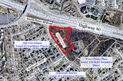
For a larger image of the site, please click HERE.
REQUESTED USES:
Permitted Uses
- Churches and other places of worship.
- Dwellings, single-family detached.
- Educational facilities--College/university, primary/secondary, kindergarten or nursery school.
- Golf courses.
- Home occupations.
- Libraries.
- Local public utility facilities, provided that any installation, other than poles and equipment attached to the poles, shall be: (a) Adequately screened with landscaping, fencing or walls, or any combination thereof; or (b) Placed underground; or (c) Enclosed in a structure in such a manner so as to blend with and complement the character of the surrounding area.
- Parks and playgrounds.
- Wildlife Reservation and Conservation Project.
Conditional uses.
- Administrative offices and educational or religious facilities.
- Child care center, nursery school, day care home.
- Clubs or community centers.
- Group residential facilities.
- Group living facilities.
- Hospitals and hospices.
- Local public utility facilities over sixty (60) feet in height, and public utility facilities.
- Mortuaries and cemeteries.
- Nursing homes and group homes for the elderly.
- Public safety facilities.
- Retreat center.
- Satellite dishes.
- Sewage treatment facilities, other than facilities permitted as an accessory use.
- Specialized private schools.
Anyone interested in the proceedings will be given an opportunity to be heard. Copies of the request are available for review in the Department of Planning and Public Works at the Chesterfield City Hall, 690 Chesterfield Parkway West during weekdays between the hours of 8:30 a.m. and 4:30 p.m. If you should need additional information about this project, please contact Mr. Kristian Corbin, Project Planner, by telephone at 636-537-4743 or by email at kcorbin@chesterfield.mo.us
CITY OF CHESTERFIELD
Amy Nolan, Chair
Chesterfield Planning Commission
Description of Property
A tract of land being part of U.S. surveys 370, 1911, 1978 and fractional sections 10 and 15, township 45 north, range 4 east, St. Louis County, Missouri and being more particularly described as follows:
Beginning at the southernmost corner of a tract of land conveyed to the Church of the Resurrection by deed book 18405 page 3041 of the St. Louis County Recorder of Deeds office, said point also being in the eastern right-of-way line of Schoettler Road (variable width). Thence northwesterly along said right-of-way the following course and distances: north 36 degrees 39 seconds 21 minutes west, a distance of 227.87 feet; thence north 53 degrees 25 minutes 56 seconds east, a distance of 22.58 feet; thence north 36 degrees 34 minutes 04 seconds west, a distance of 216.18 feet to a point of curvature to the right having a radius of 436.44 feet with a chord bearing of north 15 degrees 00 minutes 22 seconds west and a chord distance of 320.78 feet, a distance along the arc of 328.48 feet to a point. Said point being the intersection of the eastern right-of-way line of Schoettler Road (variable width) and the southern right-of-way line of Missouri State highway 40 (variable width), thence along said Missouri State highway 40 right-of-way the following course and distances; south 63 degrees 43 minutes 58 seconds east, a distance of 18.15 feet; thence south 76 degrees 20 minutes 48 seconds east, a distance of 253.41 feet; thence north 48 degrees 20 minutes 55 seconds east, a distance of 79.06 feet; thence south 76 degrees 20 minutes 48 seconds east, a distance of 52.49 feet to the northwest corner of Lot 2 of Hay Barn Lane Subdivision as recorded in plat book 179 page 77 of said County records. Thence leaving said Missouri State Highway 40 right-of-way and heading along the west line of said Lot 2 south 25 degrees 05 minutes 22 seconds west, a distance of 245.83 feet to a point; thence south 36 degrees 39 minutes 21 seconds east, a distance of 341.18 feet to an angle point in the west line of Lot 1 of said Hay Barn Lane Subdivision. Thence along the west line of said Lot 1 south 58 degrees 01 minutes 12 seconds west, a distance of 300.74 feet to the point of beginning. Containing 228,149.78 square feet or 5.23 acres more or less.