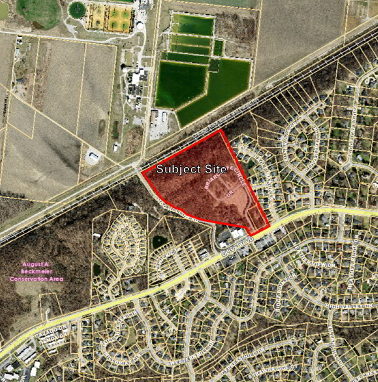
P.Z. 11-2020 The Residences at Hog Hollow (13987 & 14001 Olive Blvd)
NOTICE IS HEREBY GIVEN that the Planning Commission of the City of Chesterfield will hold a Public Hearing on Monday, December 14, 2020 at 7:00 p.m.
Due to the recommendations of the President, the Governor, and the CDC, the meeting will be conducted virtually at https://zoom.us/j/98578147504 or call in at (312) 626-6799 and enter meeting ID 985 7814 7504.
Said Hearing will be as follows:
P.Z. 11-2020 The Residences at Hog Hollow (13987 & 14001 Olive Blvd): A request to repeal City of Chesterfield Ordinance 2213 establishing a Planned Environmental Unit over two parcels of land zoned R-3 Residence District and totaling 29.4 acres (16R340207 & 16R340151).
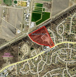
For a larger image of the site, please click HERE.
Anyone interested in the proceedings will be given an opportunity to be heard. Copies of the request are available for review in the Department of Planning at Chesterfield City Hall, 690 Chesterfield Parkway West during weekdays between the hours of 8:30 a.m. and 4:30 p.m. If you should need additional information about this project, or for a list of requested uses, please contact Ms. Annisa Kumerow, Planner, by telephone at 636-537-4743 or by email at akumerow@chesterfield.mo.us.
CITY OF CHESTERFIELD
Merrell Hansen, Chair
Chesterfield Planning Commission
PROPERTY DESCRIPTION
Part of Lot 11 of D.J. Talbots Estate Subdivision, in U.S. Surveys 2030 and 206, Township 46 North, Range 4 East, in St. Louis County, Missouri, and described as follows:
Beginning at a point in the center line of Hog Hollow Road, 40 feet wide, at its intersection with the South line of U.S. Survey 2030; thence along the center line of said road, North 45 degrees 03 minutes 31 seconds West 86.69 feet, North 74 degrees 44 minutes 26 seconds West 142.55 feet; thence North 47 degrees 14 minutes 26 seconds West 211.20 feet and North 28 degrees 14 minutes 26 seconds West 353.81 feet to a point; thence leaving said road line and running North 59 degrees 31 minutes 48 seconds East 1,249.07 feet to a point; thence South 25 degrees 49 minutes 00 seconds East 1,460.05 feet to a point in the North line of Olive Street Road, 60 feet wide; thence along the North line of Olive Street Road South 61 degrees 58 minutes 49 seconds West 294.51 feet to a point; thence North 28 degrees 33 minutes 00 seconds West 175.96 feet to a point in the South line of U.S. Survey 2030; thence along said Survey line, North 82 degrees 32 minutes 26 seconds West 854.19 feet to the POINT OF BEGINNING and containing 1,282,091 square feet or 29.433 acres more or less, according to calculations by Stock & Associates Consulting Engineers, Inc. on August 11, 2004.