P.Z. 18-2017 Falling Leaves Estates II:
NOTICE OF PUBLIC HEARING
CITY OF CHESTERFIELD
PLANNING COMMISSION
NOTICE IS HEREBY GIVEN that the Planning Commission of the City of Chesterfield will hold a Public Hearing on Monday, December 11, 2017 at 7:00 pm, in the Council Chambers at the City Hall, 690 Chesterfield Parkway West, Chesterfield, Missouri 63017.
Said Hearing will be as follows:
P.Z. 18-2017 Falling Leaves Estates II: A request to change the zoning from an existing Planned Unit Development (PUD) to a Large Lot Residential District (LLR) for a 17.4 acre tract of land located west of Wilson Avenue and northwest of the intersection of Wilson Avenue and Clarkson Road. (19T220214, 19T210161).
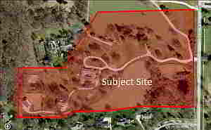
For a larger image of the site, please click HERE.
Anyone interested in the proceedings will be given an opportunity to be heard. Copies of the request are available for review in the Department of Planning and Development Services at Chesterfield City Hall, 690 Chesterfield Parkway West during weekdays between the hours of 8:30 a.m. and 4:30 p.m. If you should need additional information about this project, or for a list of requested uses, please contact Mr. Mike Knight, Project Planner, by telephone at 636-537-4736 or by email at JKnight@Chesterfield.MO.US
CITY OF CHESTERFIELD
Merrell Hansen, Chair
Chesterfield Planning Commission
PROPERTY DESCRIPTION
A tract of land being all of Lots 1 and 1A of “A Resubdivision of Lot 1 of Falling Leaves Estates” according to the plat thereof recorded in plat thereof recorded in Plat Book 327, page 88 of said records, located in Sections 16 and 21, Township 45 North, Range 4 East of the Fifth Principal Meridian, City Of Chesterfield, St. Louis County, Missouri.
Beginning at the northwest corner of above said Lot 1 of said resubdivision, thence along the north line of said Lot 1, North 88 degrees 02 minutes 40 seconds East, 714.14 feet to a point on the west line of Wilson Road, as widened, said point also being the northeast corner of said Lot 1; thence leaving last said north line and along the west right-of-way line of said Wilson Road, South 00 degrees 15 minutes 50 seconds West, 710.17 feet to the southeast corner of said Lot 1, said corner also being the northeast corner of common ground of “Wilson Farm Estates Plat 1”, a subdivision according to the plat thereof recorded in Plat Book 217 page 90 of said records; thence leaving last said west right-of-way line and along the south line of said Lot 1 and above said Lot 1A, said line also being the north line of said “Wilson Farm Estates Plat One” the following courses and distances: North 89 degrees 45 minutes 00 seconds West, 385.00 feet; South 82 degrees 26 minutes 58 seconds West, 261.68 feet; South 88 degrees 00 minutes 00 seconds West, 237.22 feet; South 65 degrees 53 minutes 25 seconds West, 108.09 feet and North 89 degrees 24 minutes 40 seconds West, 310.31 feet to a point being the southwest corner of said Lot 1A, said point also being the northwest corner of Lot 130 of said “Wilson Farm Estates Plat One”; thence leaving last said line and along the west line of said Lot 1A the following courses and distances: North 00 degrees 35 minutes 00 seconds East, 106.67 feet; North 41 degrees 00 minutes 00 seconds West, 52.26 feet; North 37 degrees 00 minutes 00 seconds East, 56.88 feet; North 00 degrees 04 minutes 20 seconds West, 169.58 feet to the northwest corner of said Lot 1A; thence with the north line of said Lot 1A and the northwest line of said Lot 1, North 89 degrees 55 minutes 40 seconds East, 325.00 feet; and North 32 degrees 02 minutes 02 seconds East, 479.18 feet to the point of beginning and containing 17.37 acres, more or less according to record information and subject to the results of a future property boundary survey.