P.Z. 13-2013 St. Luke’s Hospital-East Campus (222 S. Woods Mill Rd.)
NOTICE OF PUBLIC HEARING
CITY OF CHESTERFIELD
PLANNING COMMISSION
NOTICE IS HEREBY GIVEN that the Planning Commission of the City of Chesterfield will hold a Public Hearing on December 9, 2013 at 7:00 p.m. in the City Council Chambers at Chesterfield City Hall, 690 Chesterfield Parkway West, Chesterfield, Missouri 63017. Said Hearing will be as follows:
P.Z. 13-2013 St. Luke’s Hospital-East Campus (222 S. Woods Mill Rd.): A request for an amendment to Ordinance 2224 to modify the boundaries and development conditions of the “MU” Medical Use District located east of the intersection of South Woods Mill Road and Hwy 141 (18Q240306).
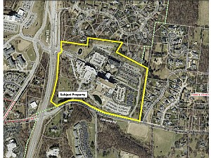
For an image of the site, please click HERE.
Anyone interested in the proceedings will be given an opportunity to be heard. Copies of the request as well as the requested uses are available for review from the Planning and Development Services Division at Chesterfield City Hall, 690 Chesterfield Parkway West, weekdays between the hours of 8:30 a.m. and 4:30 p.m. If you should need additional information about this project, please contact John Boyer, Senior Planner by telephone at 636-537-4734 or by email at jboyer@chesterfield.mo.us.
CITY OF CHESTERFIELD
Michael Watson, Chair
Chesterfield Planning Commission
Description of Property
PARCEL A
A tract of land in U.S. Survey 365, Township 45 North, Range 5 East, St. Louis County, Missouri, and being more particularly described as:
Beginning at the intersection of the West line of property conveyed to William McCurdy, Jr. by deed recorded in Book 7086 Page 1660 of the St. Louis County Records with a South line of "LADUE FARMS ESTATES PLAT THREE", a subdivision according to the plat thereof recorded as Daily No. 483 on July 14, 1978 in the Sl. Louis County Records; thence Southwardly along the said West line of the McCurdy property South 31 degrees 01 minutes 51 seconds West 236.13 feet to the Southwest corner thereof; thence Eastwardly along the south line of said McCurdy property and the South line of property conveyed to Paul B. Akin and wife by deed recorded in Book 6264 Page 288 of the St. Louis County Records, South 63 degrees 38 minutes 59 seconds East 742.99 feet to a point in the West line of property conveyed to Paul B. Akin and wife by deed recorded in Book 3966 Page 563 of the St. Louis County Records; thence Southwardly along the said West line of the Akin property, South 09 degrees 25 minutes 36 seconds West, 1,128.12 feet to a point in the relocated North line of Conway Road as dedicated by "Right-of-way Dedication Survey" recorded in Book 6746 Page 1419 of the St. Louis County Records; thence Westwardly along said relocated North line of Conway Road, the following courses and distances: North 76 degrees 34 minutes 00 seconds West 23.90 feet, North 62 degrees 31 minutes 50 seconds West 41.23 feet, North 76 degrees 34 minutes 00 seconds West 320.00 feet, North 87 degrees 52 minutes 36 seconds West 50.99 feet, North 76 degrees 34 minutes 00 seconds West 258.22 feet, along a curve to the right whose radius point bears North 13 degrees 26 minutes 00 seconds East 924.93 feet from the last mentioned point, a distance of 282.86 feet, North 59 degrees 02 minutes 40 seconds West 236.22 feet, along a curve to the left whose radius point bears South 30 degrees 57 minutes 20 seconds West 439.26 feet from the last mentioned point, a distance of 125.76 feet, North 60 degrees 20 minutes 00 seconds West 5.70 feet, South 86 degrees 31 minutes 00 seconds West 5.20 feet, along a curve to the left whose radius point bears South 13 degrees 11 minutes 17 seconds West 439.26 feet from the last mentioned point, a distance of 109.56 feet, along a curve to the left whose radius point bears South 01 degrees 06 minutes 09 seconds East 597.23 feet from the last mentioned point, a distance of 153.82 feet, and South 74 degrees 06 minutes 30 seconds West 248.99 feet to a point being 102.00 feet perpendicularly distant Northwest of said relocated Conway Road centerline Station 16+21.12 feet, said point being also in the East line of property conveyed to the Missouri Highway and Transportation Commission by deed recorded in Book 7736 Page 1197 of the St. Louis County Records, said property conveyed to the Missouri Highway and Transportation Commission for State Route 141 relocation; thence along said East line of State Route 141 (relocated) the following courses and distances: North 43 degrees 36 minutes 10 seconds West 87.41 feet to a point being 122 feet radially distant East of Missouri state Route 141 (relocated) centerline Station 112+00; thence along a curve to the left whose radius point bears North 74 degrees 27 minutes 45 seconds West 3,941.72 feet from the last mentioned point 878.98 feet to a point being 122.00 feet radially distant East of Missouri Route 141 (relocated) centerline Station 103+48.21; thence along a line being 122.00 feet perpendicularly distant East of and parallel to the said centerline of Missouri State Route 141 (relocated) North 02 degrees 45 minutes 39 seconds East 139.21 feet to a point being opposite centerline Station 102+09; thence North 67 degrees 51 minutes 22 seconds East 61.74 feet to a point being 178.00 feet East of Missouri State Route 141 (relocated) centerline Station 101+83; thence North 12 degrees 46 minutes 08 seconds East 51.79 feet to a point being 187.00 feet East of Missouri State Route 141 (relocated) centerline Station 101+32; thence North 04 degrees 12 minutes 18 seconds East 119.04 feet to a point being 190.00 feet East of Missouri Route 141 (relocated) centerline Station 100+13; thence North 07 degrees 03 minutes 00 seconds East 39.46 feet to a point, in the South line of "Ladue Farm Estates Plat One", a subdivision according to the plat thereof recorded as Daily Number 268 on August 28, 1979 in the St. Louis County Records; thence leaving the aforesaid East line of Missouri State Route 141 (relocated) as described by deed recorded in Book 7736 page 1197 of the St. Louis County Records Eastwardly along the said South line of "Ladue Farm Estates Plat One" and a South line of aforesaid "Ladue Farm Estates Plat Three" South 81 degrees 47 minutes 43 seconds East 520.18 feet to a point; thence continuing along the boundary line of said "Ladue Farm Estates Plat Three" North 08 degrees 07 minutes 33 seconds East 160.94 feet and South 81 degrees 47 minutes 43 seconds East 704.43 feet to the point of beginning.