NOTICE OF PUBLIC HEARING
CITY OF CHESTERFIELD
PLANNING COMMISSION
NOTICE IS HEREBY GIVEN that the Planning Commission of the City of Chesterfield will hold a Public Hearing on Monday, November 14, 2016 at 7:00 p.m. in the City Council Chambers at Chesterfield City Hall, 690 Chesterfield Parkway West, Chesterfield, Missouri 63017.
Said Hearing will be as follows:
P.Z. 08-2016 Breckenridge Materials (17971 N. Outer 40 Rd.): A request for a zoning map amendment from an “FPM3” Floodplain Planned Industrial District to a “PI” Planned Industrial District for a 2.688 acre area of land on a portion of the property at 17971 N. Outer 40 Rd., located on the north side of North Outer 40 Rd., east of the Missouri River. (a 2.688 acre portion of 16W240041).
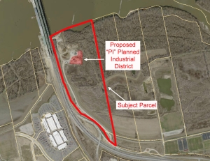
For a larger image of the site, please click HERE.
REQUESTED USE:
Batching Plant
Anyone interested in the proceedings will be given an opportunity to be heard. Copies of the request are available for review in the Department of Public Services at Chesterfield City Hall, 690 Chesterfield Parkway West during weekdays between the hours of 8:30 a.m. and 4:30 p.m. If you should need additional information about this project, please contact Mr. Justin Wyse, Senior Planner, by telephone at 636-537-4734 or by email at jwyse@chesterfield.mo.us
CITY OF CHESTERFIELD
Stanley Proctor, Chair
Chesterfield Planning Commission
PROPERTY DESCRIPTION
A tract of land being part of property conveyed to St. Charles Sand Company by deed recorded in Deed Book 6033, Page 294 of the St. Louis County Records, in U.S. Survey 368, Township 45 North, Range 3 East, St. Louis County, Missouri and being more particularly described as follows:
Commencing at point on the east line of Missouri State Highway 40 TR, being 183.00 feet east of Centerline P.C. Station 43+40.72; thence northwardly along said east line of Missouri State Highway 40 TR North 15 degrees 40 minutes 37 seconds West 276.24 feet to a point; thence leaving said road line North 74 degrees 19 minutes 23 second East 353.38 feet to the actual point of beginning; thence North 2 degrees 15 minutes 22 second East 107.10 feet to a point; thence along a curve to the left whose radius point bears North 34 degrees 06 minutes 34 seconds West 91.89 feet from the last mentioned point, a distance of 67.80 feet to a point; thence along a curve to the right whose radius point bears South 82 degrees 47 minutes 17 seconds East 81.66 feet from the last mentioned point, a distance of 89.78 feet to a point; thence North 77 degrees 03 minutes 26 seconds East 95.98 feet to a point; thence North 87 degrees 01 minutes 46 seconds East 43.70 feet to a point; thence North 03 degrees 40 minutes 22 seconds East 136.97 feet to a point; thence North 84 degrees 13 minutes 01 seconds East 39.44 feet to a point; thence North 75 degrees 13 minutes 09 seconds East 91.87 feet to a point; thence South 13 degrees 44 minutes 39 seconds East 96.74 feet to a point; thence South 06 degrees 18 minutes 01 seconds East 76.34 feet to a point; thence South 03 degrees 39 minutes 17 seconds West 271.47 feet to a point; thence North 86 degrees 17 minutes 24 seconds West 384.26 feet to the actual point of beginning and containing 2.7 acres.