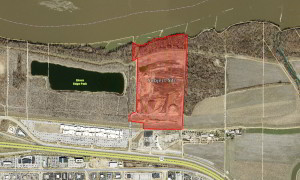
P.Z. 14-2019 16849 N Outer 40 Rd. (FPNU to AG)
NOTICE IS HEREBY GIVEN that the Planning Commission of the City of Chesterfield will hold a Public Hearing on Wednesday, November 13, 2019 at 7:00 p.m. in the Council Chambers at Chesterfield City Hall, 690 Chesterfield Parkway West, Chesterfield Missouri 63017.
Said Hearing will be as follows:
P.Z. 14-2019 16849 N Outer 40 Rd. (FPNU to AG): A change in zoning from a “FPNU” Floodplain Non-Urban District to an “AG” Agricultural District for an 84.594 acre tract of land located at 16849 N. Outer 40 Road; north of the Monarch Chesterfield Levee.
Anyone interested in the proceedings will be given an opportunity to be heard. Copies of the request are available for review in the Department of Planning & Development Services at Chesterfield City Hall, 690 Chesterfield Parkway West during weekdays between the hours of 8:30 a.m. and 4:30 p.m. If you should need additional information about this project, or for a list of uses, please contact Ms. Annisa Kumerow, Planner, by telephone at 636-537-4743 or by email at akumerow@chesterfield.mo.us.
CITY OF CHESTERFIELD
Merrell Hansen, Chair
Chesterfield Planning Commission
PROPERTY DESCRIPTION
A tract of land being a composite of those parcels of land conveyed to Wayne D. Hayes and Ruthann E. Haynes, his wife, by deed recorded in Deed Book 9054, Page 2041 and Deed Book 9054, Page 2044 of the St. Louis County Records, being part of Lots 4, 5, 6 and 7 of James Long’s Estate in U.S. Survey 2031, Township 45 North-Range 4 East, St. Louis County, Missouri and being more particularly described as:
Beginning at the intersection of the North line of property conveyed to Carl R. Tisone, by deed recorded in Book 10619 page 1347 of the St. Louis County Records with the West line of property conveyed to Walter E. and Jo Ann Graeler by deed recorded in Book 9049 page 1848 of the St. Louis County Records, said West line being the East line of said Lot 7 of James Long’s Estate; thence Westwardly along said North line of property conveyed to Carl R. Tisone, along the North line of property conveyed to U.S. Ice Sports Complex, L.C., by deed recorded in Book 11291 page 68 of the St. Louis County Records, along the North line of property conveyed to U.S. Ice Sports Complex, L.C. (Parcel No. 1) by deed recorded in Book 10346 page 126 of the St. Louis County Records the following courses and distances: North 79 degrees 04 minutes 06 seconds West 24.48 feet, North 88 degrees 38 minutes 29 seconds West 277.05 feet, South 87 degrees 23 minutes 35 seconds West 36.47 feet, South 87 degrees 39 minutes 34 seconds West 316.34 feet, North 86 degrees 58 minutes 10 seconds West 209.16 feet, North 87 degrees 00 minutes 21 seconds West 188.72 feet, South 84 degrees 43 minutes 08 seconds West 44.91 feet, South 50 degrees 31 minutes 21 seconds West 28.78 feet to a point; thence leaving said North line North 07 degrees 30 minutes 12 seconds East 193.50 feet to a point; thence North 82 degrees 29 minutes 48 seconds West 414.08 feet to the East line of property described in Deed to the Monarch-Chesterfield Levee District recorded in Book 11936 page 867 of the St. Louis County Records; thence Northwardly along said East line the following courses and distances: North 02 degrees 24 minutes 53 seconds East 168.12 feet, North 28 degrees 22 minutes 48 seconds East 46.99 feet, North 62 degrees 13 minutes 56 seconds East 171.64 feet, North 01 degree 33 minutes 03 seconds East 890.42 feet, North 02 degrees 31 minutes 09 seconds East 653.97 feet and South 62 degrees 41 minutes 26 seconds West 184.34 feet to said East line of East 653.97 feet and South 62 degrees 41 minutes 26 seconds West 184.34 feet to said East line of property conveyed to Monarch-Chesterfield Levee District; thence North 02 degrees 31 minutes 06 seconds East 510.99 feet along said East line of property conveyed to the Monarch-Chesterfield Levee District to the top of bank of the Missouri River as located by Volz, Inc. on October 16, 1998; thence Eastwardly along said top of bank of the Missouri River as located by Volz, Inc. on October 16, 1998 the following courses and distances: North 87 degrees 43 minutes 55 seconds East 48.62 feet, South 57 degrees 12 minutes 08 seconds East 158.27 feet, North 71 degrees 14 minutes 43 seconds East 302.67 feet, North 59 degrees 25 minutes 18 seconds East 146.61 feet, North 55 degrees 21 minutes 14 seconds East 88.95 feet, North 89 degrees 19 minutes 38 seconds East 162.39 feet, North 71 degrees 52 minutes 15 seconds East 153.73 feet, North 82 degrees 12 minutes 01 second East 188.18 feet, North 77 degrees 29 minutes 23 seconds East 212.25 feet, North 88 degrees 30 minutes 02 seconds East 146.64 feet, South 23 degrees 37 minutes 07 seconds East 72.07 feet and South 62 degrees 53 minutes 26 seconds East 35.79 feet to the West line of property conveyed to Clarkson Property Company, by deed recorded in Book 9307 page 1665 of the St. Louis County Records, said West line being the East line of said Lot 7 of James Long’s Estate; thence South 03 degrees 35 minutes 45 seconds West 2,673.05 feet along said West line of property conveyed to Clarkson Property Company being the East line of said Lot 7 of James Long’s Estate to the Northwest corner of said property conveyed to Walter E. and Jo Ann Graeler; thence Long’s Estate to the point of beginning and containing 84.594 acres according to calculations by Volz, Inc. during December 2006; said tract of land also described as Adjusted Lot 2 of “Haynes Boundary Adjustment Plat” recorded in Plat Book 357, Page 3 of the St. Louis County Records.