P.Z. 09-2014 Bur Oaks (17751 Wild Horse Creek Road):
NOTICE OF PUBLIC HEARING
CITY OF CHESTERFIELD
PLANNING COMMISSION
NOTICE IS HEREBY GIVEN that the Planning Commission of the City of Chesterfield will hold a Public Hearing on Monday, October 27, 2014 at 7:00 p.m. in the City Council Chambers at Chesterfield City Hall, 690 Chesterfield Parkway West, Chesterfield, Missouri 63017.
Said Hearing will be as follows:
P.Z. 09-2014 Bur Oaks (17751 Wild Horse Creek Road): A request for a zoning map amendment from an “NU” Non-Urban District to an “E-1/2AC” Estate District with a Wild Horse Creek Overlay District designation for 21.876 acres located on the north side of Wild Horse Creek Road west of its intersection of Long Road and east of its intersection with Savonne Court (18V510105).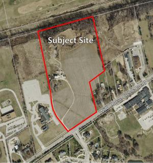
For a larger image of the site, please click HERE.
REQUESTED USES:
- Dwellings, single-family detached.
Anyone interested in the proceedings will be given an opportunity to be heard. Copies of the request are available for review in the Department of Public Services at Chesterfield City Hall, 690 Chesterfield Parkway West during weekdays between the hours of 8:30 a.m. and 4:30 p.m. If you should need additional information about this project, please contact Mr. Jonathan Raiche, Senior Planner, by telephone at 636-537-4736 or by email at jraiche@chesterfield.mo.us
CITY OF CHESTERFIELD
Mike Watson, Chair
Chesterfield Planning Commission
PROPERTY DESCRIPTION
A tract of land being Part of Lot 1 of Mary Schaeffer Estates Subdivision, as recorded in Plat Book 17, Page 4 of the St. Louis County Records and part of Share 6 of the Partition of the Estate of Missouri A Stevens, also part of Lot 24 of R.H. Stevens Farm Subdivision, located in U.S. Survey 122, Township 45 North, Range 3 East of the Fifth Principal Meridian, City of Chesterfield, St. Louis County, Missouri being more particularly described as follows:
Beginning at a found Iron Pipe located at the intersection of the northern right-of-way line of Wild Horse Creek Road, variable width, with the western line a tract of land as conveyed to John Wilmas, by instrument recorded in Book 12756, Page 2437 of above said records; thence along said right-of-way line, South 55 degrees 15 minutes 47 seconds West, 481.15 feet to a found Iron Pipe at the eastern line of a tract of land as conveyed CDF Holdings, LLC by instrument recorded in Book 18588, Page 2418 of above said records; thence along the eastern line of said CDF Holdings, LLC tract the following courses and distances: North 13 degrees 12 minutes 14 seconds West, 5.15 feet to a found Iron Pipe; North 40 degrees 09 minutes 05 seconds West, 69.35 feet to a found Iron Pipe; North 37 degrees 11 minutes 51 seconds West, 172.32 feet to the beginning of a non-tangent curve to the right having a radius of 413.50 feet, from which a found Iron Pipe bears North 58 degrees 28 minutes 05 seconds East, 0.43 feet; along said curve with an arc length of 209.79 feet and a chord which bears North 21 degrees 38 minutes 46 seconds West, 207.54 feet; North 07 degrees 12 minutes 28 seconds West, 266.41 feet; North 11 degrees 03 minutes 11 seconds West, 64.81 feet and North 11 degrees 40 minutes 19 seconds West, 692.78 feet to the southern right-of-way line of the Chicago Rock Island and Pacific Rail Road,100 feet wide, from which a found Iron Pipe bears South 70 degrees 11 minutes 48 seconds East, 0.56 feet; thence along said right-of-way line, North 74 degrees 47 minutes 19 seconds East, 777.36 feet to the northwest corner of a tract of land as conveyed to Vision Ventures, LLC by instrument recorded in Book 18974, Page 1757 of above said records, from which a found Iron Pipe bears South 58 degrees 15 minutes 52 seconds East, 1.00 feet; thence along the western line of said Vision Ventures, LLC tract, South 12 degrees 36 minutes 00 seconds East, 783.00 feet to the northeast corner of a tract of land as conveyed to Emil & Loretta Tomschin by instrument recorded in Book 16601, Page 462 of above said records, from which a found Iron Pipe bears South 60 degrees 11 minutes 01 seconds East, 0.48 feet; thence along the northern lines of said Tomschin and above said Wilmas tracts, South 55 degrees 15 minutes 47 seconds West, 250.88 feet to the northwest corner of said Wilmas tract from which a found Iron Pipe bears South 59 degrees 05 minutes 01 seconds East, 0.41 feet; thence along the western line of said Wilmas tract , South 12 degrees 36 minutes 00 seconds East, 134.45 feet; thence departing last said western line the following courses and distances: South 59 degrees 19 minutes 34 seconds West, 31.56 feet; South 12 degrees 36 minutes 00 seconds East, 15.26 feet and South 30 degrees 00 minutes 01 seconds East, 100.32 feet to the western line of said Wilmas tract; thence along said western line, South 12 degrees 36 minutes 00 seconds East, 172.34 feet to the Point of Beginning and containing 952,958 square feet or 21.876 acres more or less as per a survey by Stock & Associates Consulting Engineers, Inc. during March, 2014.