P.Z. 09-2015 Friendship Village of West County (15239, 15249 & 15255 Olive Blvd)
NOTICE OF PUBLIC HEARING
CITY OF CHESTERFIELD
PLANNING COMMISSION
NOTICE IS HEREBY GIVEN that the Planning Commission of the City of Chesterfield will hold a Public Hearing on Monday, October 26, 2015 at 7:00 p.m. in the City Council Chambers at Chesterfield City Hall, 690 Chesterfield Parkway West, Chesterfield, Missouri 63017.
Said Hearing will be as follows:
P.Z. 09-2015 Friendship Village of West County (15239, 15249 & 15255 Olive Blvd): A request for a zoning map amendment from a “NU” Non-Urban District to a “R-4” Residential District for 2.13 acres located at the northeast corner of Olive Boulevard and Braefield Drive (18S640272, 18S640326 & 18S640162).
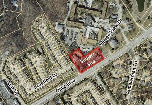
For a larger image of the site, please click HERE.
For requested uses, please contact the Project Planner.
Anyone interested in the proceedings will be given an opportunity to be heard. Copies of the request are available for review in the Department of Public Services at Chesterfield City Hall, 690 Chesterfield Parkway West during weekdays between the hours of 8:30 a.m. and 4:30 p.m. If you should need additional information about this project, please contact Ms. Purvi Patel, Project Planner, by telephone at 636-537-4738 or by email at ppatel@chesterfield.mo.us
CITY OF CHESTERFIELD
Stanley Proctor, Chair
Chesterfield Planning Commission
PROPERTY DESCRIPTION
A tract of land being part of Lot 2 of Hugo Essen Farm in U. S. Survey 154 & 157, Township 45, North, Range 4 East in St. Louis County, Missouri, being more particularly described as follows: beginning at a point on the Northern right of way line of Olive Boulevard (variable width) and the Eastern line of Braefield, a subdivision recorded in Plat Book 331 Pages 80 and 81 of the St. Louis County Land Records Office, from which a found 1/2" Rebar bears South 30 degrees 34 minutes East, 0.25 feet; thence along the Eastern line of Braefield subdivision, North 30 degrees 33 minutes 39 seconds West a distance of 304.53 feet to a set 1/2" x 18" rebar with cap stamped "Marler 347-D" (Typical) being on the Southern line of Lot A of Friendship Village of West County Boundary Adjustment Plat, as recorded in Plat Book 356 Page 143; thence along the Southern line of said Lot A, North 57 degrees 43 minutes 34 seconds East a distance of 158.84 feet to a found 3/4" iron pipe; South 30 degrees 35 minutes 40 seconds East a distance of 134.92 feet to a point from which a found 3/4" iron pipe bears North 16 degrees 00 minutes East 0.13 feet; North 57 degrees 46 minutes 10 seconds East a distance of 242.96 feet to a point from which a found 1/2" rebar with cap stamped "L.S. 134-D" bears South 00 degrees 43 minutes, 0.11 feet; South 30 degrees 31 minutes 42 seconds East a distance of 180.48 feet to a set rebar on the Northern right of way line of Olive Boulevard; Thence along said Northern right of way line, South 58 degrees 21 minutes 41 seconds West a distance of 343.27 feet to a found 5/8" rebar with an aluminum cap; thence South 63 degrees 56 minutes 01 seconds West a distance of 41.19 feet to a point from which a found 5/8" rebar with an aluminum cap bears south 0.1 feet; thence South 66 degrees 53 minutes 32 seconds West a distance of 17.48 feet to the point of beginning containing 92,900 square feet or 2.13 acres more or less as surveyed by Marler Surveying Company Inc.
Said Hearing will be as follows:
P.Z. 09-2015 Friendship Village of West County (15239, 15249 & 15255 Olive Blvd): A request for a zoning map amendment from a “NU” Non-Urban District to a “R-4” Residential District for 2.13 acres located at the northeast corner of Olive Boulevard and Braefield Drive (18S640272, 18S640326 & 18S640162).
For a larger image of the site, please click HERE.
For requested uses, please contact the Project Planner.
Anyone interested in the proceedings will be given an opportunity to be heard. Copies of the request are available for review in the Department of Public Services at Chesterfield City Hall, 690 Chesterfield Parkway West during weekdays between the hours of 8:30 a.m. and 4:30 p.m. If you should need additional information about this project, please contact Ms. Purvi Patel, Project Planner, by telephone at 636-537-4738 or by email at ppatel@chesterfield.mo.us
CITY OF CHESTERFIELD
Stanley Proctor, Chair
Chesterfield Planning Commission
PROPERTY DESCRIPTION
A tract of land being part of Lot 2 of Hugo Essen Farm in U. S. Survey 154 & 157, Township 45, North, Range 4 East in St. Louis County, Missouri, being more particularly described as follows: beginning at a point on the Northern right of way line of Olive Boulevard (variable width) and the Eastern line of Braefield, a subdivision recorded in Plat Book 331 Pages 80 and 81 of the St. Louis County Land Records Office, from which a found 1/2" Rebar bears South 30 degrees 34 minutes East, 0.25 feet; thence along the Eastern line of Braefield subdivision, North 30 degrees 33 minutes 39 seconds West a distance of 304.53 feet to a set 1/2" x 18" rebar with cap stamped "Marler 347-D" (Typical) being on the Southern line of Lot A of Friendship Village of West County Boundary Adjustment Plat, as recorded in Plat Book 356 Page 143; thence along the Southern line of said Lot A, North 57 degrees 43 minutes 34 seconds East a distance of 158.84 feet to a found 3/4" iron pipe; South 30 degrees 35 minutes 40 seconds East a distance of 134.92 feet to a point from which a found 3/4" iron pipe bears North 16 degrees 00 minutes East 0.13 feet; North 57 degrees 46 minutes 10 seconds East a distance of 242.96 feet to a point from which a found 1/2" rebar with cap stamped "L.S. 134-D" bears South 00 degrees 43 minutes, 0.11 feet; South 30 degrees 31 minutes 42 seconds East a distance of 180.48 feet to a set rebar on the Northern right of way line of Olive Boulevard; Thence along said Northern right of way line, South 58 degrees 21 minutes 41 seconds West a distance of 343.27 feet to a found 5/8" rebar with an aluminum cap; thence South 63 degrees 56 minutes 01 seconds West a distance of 41.19 feet to a point from which a found 5/8" rebar with an aluminum cap bears south 0.1 feet; thence South 66 degrees 53 minutes 32 seconds West a distance of 17.48 feet to the point of beginning containing 92,900 square feet or 2.13 acres more or less as surveyed by Marler Surveying Company Inc.