P.Z. 10-2019 Downtown Chesterfield (Thompson Thrift Development, Inc.)
NOTICE OF PUBLIC HEARING
CITY OF CHESTERFIELD
PLANNING COMMISSION
NOTICE IS HEREBY GIVEN that the Planning Commission of the City of Chesterfield will hold a Public Hearing on Monday, September 9, 2019 at 7:00 p.m. in the Council Chambers at Chesterfield City Hall, 690 Chesterfield Parkway West, Chesterfield Missouri 63017.
Said Hearing will be as follows:
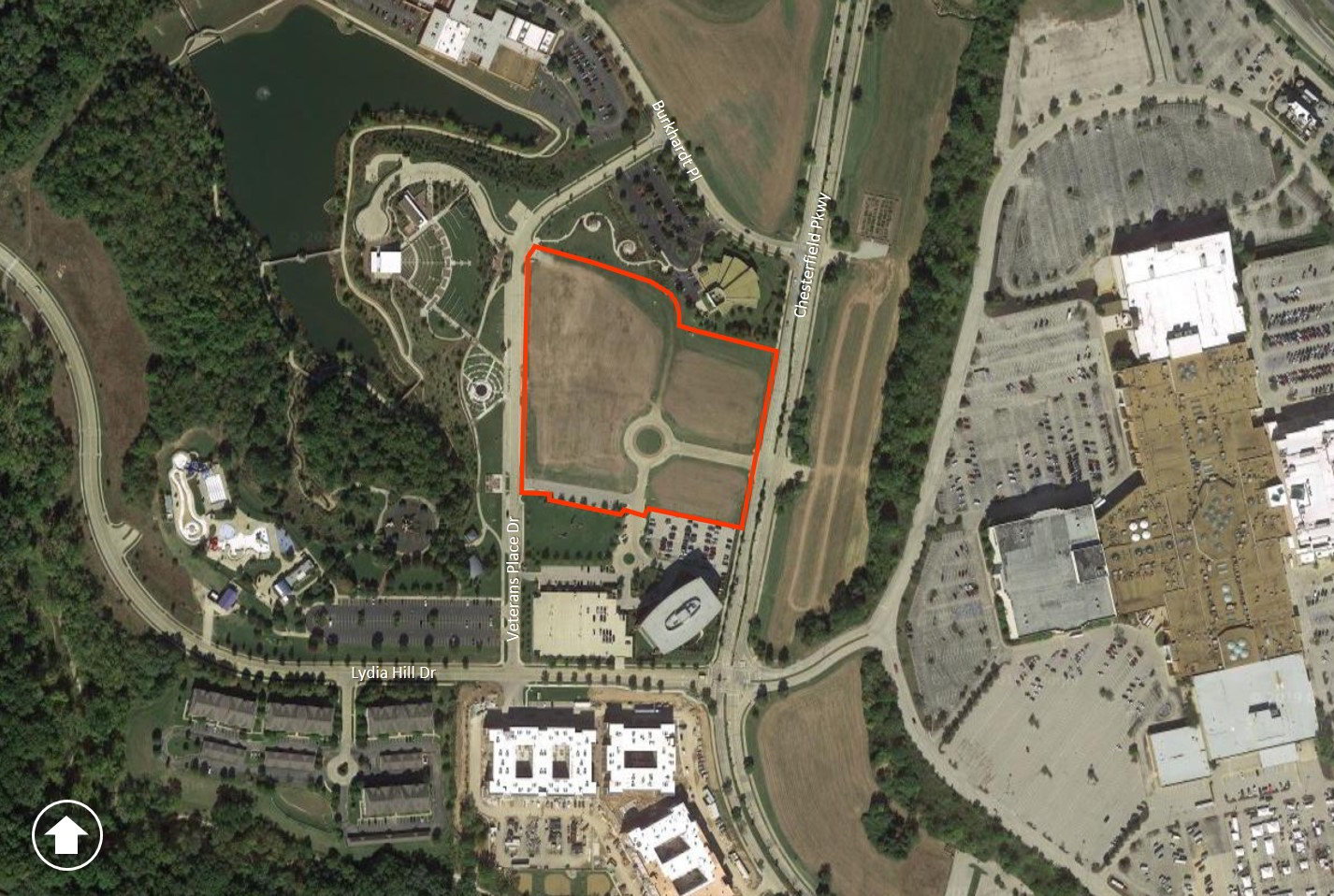
P.Z. 10-2019 Downtown Chesterfield (Thompson Thrift Development, Inc.): A request for a zoning map amendment from a “C-8” Planned Commercial District to a “UC” Urban Core District to permit residential dwelling units in addition to the existing permitted commercial uses for an 8.7 acre area of land located at the intersection of Chesterfield Parkway and Park Circle Drive and along the east side of Veterans Place Drive (18S110159, 18S110160, 18S130179, 18S130180, 18S130201, 18T340322, 18T340366).

For a larger image of the site, please click HERE.
Anyone interested in the proceedings will be given an opportunity to be heard. Copies of the request are available for review in the Department of Planning & Development Services at Chesterfield City Hall, 690 Chesterfield Parkway West during weekdays between the hours of 8:30 a.m. and 4:30 p.m. If you should need additional information about this project, or for a list of requested uses, please contact Mr. Andrew Stanislav, Planner, by telephone at 636-537-4738 or by email at astanislav@chesterfield.mo.us.
CITY OF CHESTERFIELD
Merrell Hansen, Chair
Chesterfield Planning Commission
PROPERTY DESCRIPTION
A tract of land being Lots 3, 4, 5, 6, 7 and Common Area of Downtown Chesterfield Plat One, a subdivision according to the plat thereof as recorded in Plat Book 357, Pages 185 and 186 of the St. Louis County records, located in part of U.S. Surveys 415 and 2002, Township 45 North, Range 4 East of the Fifth Principal Meridian City of Chesterfield, St. Louis County, Missouri being more particularly described as follows:
Beginning at the southwest corner of above said Lot 3, said point also being located on the east right-of-way line of Veterans Place Drive 50 feet wide as established by the road dedication plat thereof as recorded in Plat Book 359, Page 87 of above said records; thence along said right-of-way line, North 00 degrees 40 minutes 13 seconds East, 603.17 feet to a point of curvature to the right having a radius of 200.00 feet; thence along said curve with an arc length of 28.62 feet to the beginning of a non-tangential curve to the right having a radius of 39.50 feet, said point also being located on the southern right-of-way line of Main Circle Drive, variable width; thence along the southern and western right-of-way lines of said Main Circle Drive the following courses and distances: along said curve with an arc length of 31.88 feet and a chord which bears North 83 degrees 57 minutes 41 seconds East, 30.35 feet to a point of tangency; South 65 degrees 04 minutes 46 seconds East, 57.25 feet to the beginning of a curve to the left, having a radius of 165.50 feet, an arc length of 38.59 feet and a chord which bears South 71 degrees 45 minutes 24 seconds East, 38.48 feet to a point of tangency; South 78 degrees 25 minutes 56 seconds East, 158.91 feet to a point of curvature to the right having a radius of 144.50 feet, an arc length of 104.00 feet and a chord which bears South 57 degrees 49 minutes 12 seconds East, 72.62 feet; thence departing said right-of-way line, crossing above said Main Circle Drive, along a radial line, North 83 degrees 46 minutes 08 seconds East, 48.00 feet to the eastern right-of-way line of said Main Circle Drive, said point being the northwest corner of above said Common Ground Area; thence along the common lines of said Common Area and Lots 9 and 8 of above said Downtown Chesterfield Plat One, South 79 degrees 56 minutes 27 seconds East, 277.79 feet to the west right-of-way line of Chesterfield Parkway, 73 feet wide; thence along said right-of-way line the following courses and distances: South 10 degrees 03 minutes 33 seconds West, 27.36 feet to a point of curvature to the right having a radius of 2,963.50 feet and an arc length of 78.03 feet and a chord which bears South 10 degrees 48 minutes 49 seconds West, 78.03 feet and South 11 degrees 34 minutes 04 seconds West, 401.91 feet to the southeast corner of above said Lot 5; thence along the west lines of said Lot 5 and above said Lot 4, North 78 degrees 25 minutes 56 seconds West, 283.72 feet to the east right-of-way line of above said Main Circle Drive; thence crossing said Main Circle Drive, North 80 degrees 21 minutes 04 seconds West, 36.00 feet to the west right-of-way line thereof; thence along said right-of-way line the following courses and distances; South 09 degrees 38 minutes 56 seconds West, 7.37 feet; North 80 degrees 21 minutes 04 seconds West, 13.20 feet and South 09 degrees 38 minutes 56 seconds West, 25.00 feet to the southeasternmost corner of above said Lot 3; thence along the common line between said Lot 3 and Lot 2 of above said Downtown Chesterfield Plat One the following courses and distances: North 80 degrees 21 minutes 04 seconds West, 220.13 feet; North 09 degrees 38 minutes 56 seconds East, 25.00 feet; North 80 degrees 21 minutes 04 seconds West, 10.65 feet to the beginning of a curve to the left having a radius of 281.00 feet; along said curve with an arc length of 44.03 feet and a chord which bears North 84 degrees 50 minutes 27 seconds West, 43.98 feet to a point of tangency and North 89 degrees 19 minutes 47 seconds West, 12.20 feet to the POINT OF BEGINNING.
Containing 379,432 square feet or 8.711 acres, more or less, this description was prepared from available record information and is therefore subject to an actual boundary survey.