P.Z. 04-2016 US Ice Sports Complex & Valley Gates (Topgolf USA Chesterfield LLC)
NOTICE OF PUBLIC HEARING
CITY OF CHESTERFIELD
PLANNING COMMISSION
NOTICE IS HEREBY GIVEN that the Planning Commission of the City of Chesterfield will hold a Public Hearing on Monday, June 27, 2016 at 7:00 p.m. in the City Council Chambers at Chesterfield City Hall, 690 Chesterfield Parkway West, Chesterfield, Missouri 63017.
Said Hearing will be as follows:
P.Z. 04-2016 US Ice Sports Complex & Valley Gates (Topgolf USA Chesterfield LLC): A request for a zoning map amendment from an existing “PC” Planned Commercial District to a new “PC” Planned Commercial District for 22.22 acres located north of North Outer 40 Road and east of Boone’s Crossing (17T510041, 17T520062, 17T520095, 17T520084).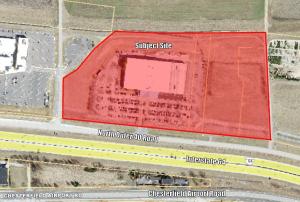
For a larger image of the site, please click HERE.
For a list of the Requested Uses, please click HERE.
Anyone interested in the proceedings will be given an opportunity to be heard. Copies of the request are available for review in the Department of Public Services at Chesterfield City Hall, 690 Chesterfield Parkway West during weekdays between the hours of 8:30 a.m. and 4:30 p.m. If you should need additional information about this project, please contact Mr. Jonathan Raiche, Senior Planner, by telephone at 636-537-4736 or by email at jraiche@chesterfield.mo.us
CITY OF CHESTERFIELD
Stanley Proctor, Chair
Chesterfield Planning Commission
PROPERTY DESCRIPTION
A tract of land being a tract of land as conveyed to Summit Ice Center Investors, LLC by instrument recorded in Book 14970, Page 648 and Lots A and B of Valley Gates, a subdivision according to the plat thereof as recorded in Plat Book 356, page 688 both of the St. Louis County Records, located in U.S. Survey 2031, Township 45, North, Range 4 East of the Fifth Principal Meridian, City of Chesterfield, St. Louis County, Missouri being more particularly described as follows:
Beginning at the intersection of the west line of Lot 5 of James Long Estate, according to the plat thereof as recorded in Book 445, Page 354 of the City of St. Louis records, also being the east line of a tract of land as conveyed to Taubman Prestige Outlets of Chesterfield, LLC by instrument recorded in Book 20091, page 1215 of above said county records and the north right-of-way line of Missouri State Highway Route 40 TR Relocated, variable width, as recorded in Book 6343, page 868 of also of above said county records, said point being located 190 feet north of the centerline of said highway; thence along the east line of said Taubman tract the following courses and distances, North 01 degree 36 minutes 28 seconds East, 288.84 feet; North 66 degrees 52 minutes 23 seconds East, 42.59 feet; North 52 degrees 55 minutes 22 seconds East, 83.69 feet; North 43 degrees 35 minutes 48 seconds East, 119.08 feet; North 38 degrees 40 minutes 37 seconds East, 130.29 feet and North 50 degrees 31 minutes 21 seconds East, 99.71 feet to the southern line of a tract of land as conveyed to Wayne D & Ruthann E Hayes, by instrument recorded in Book 9054, Page 2041 of said county records; thence along said southern line the following courses and distances: North 50 degrees 31 minutes 21 seconds East, 28.80 feet; North 84 degrees 43 minutes 06 seconds East, 44.91 feet; South 87 degrees 00 minutes 22 seconds East, 188.72 feet; South 86 degrees 58 minutes 09 seconds East, 209.17 feet and North 87 degrees 39 minutes 35 seconds East, 260.46 feet to the northwest corner of above said Valley Gates Subdivision; thence along the north line of said subdivision the following courses and distances, North 87 degrees 39 minutes 35 seconds East, 92.35 feet; South 88 degrees 38 minutes 39 seconds East, 277.05 feet and South 78 degrees 44 minutes 00 seconds East, 24.29 feet to the northeast corner of said subdivision; thence along the east line of said Valley Gates Subdivision, South 02 degrees 22 minutes 06 seconds East, 775.95 feet to the north line of above said Missouri State Highway 40 TR, said point also being located on a curve to the left having a radius of 3054.79 feet; thence along said right-of-way line the following; along said curve with an arc length of 225.28 feet and a chord which bears North 82 degrees, 00 minutes 08 seconds West, 225.22 feet to a point of tangency and North 84 degrees 06 minutes 54 seconds West, 1287.96 feet to the Point of Beginning, containing 967,827 square feet or 22.218 acres more or less according to calculations performed by Stock & Associates Consulting Engineers, Inc. on February 29, 2016.