P.Z. 05-2018 Edison Crossing (Buttry & Brown Development)
NOTICE OF PUBLIC HEARING
CITY OF CHESTERFIELD
PLANNING COMMISSION
NOTICE IS HEREBY GIVEN that the Planning Commission of the City of Chesterfield will hold a Public Hearing on Wednesday, May 30, 2018 at 7:00 p.m. in the Council Chambers at Chesterfield City Hall, 690 Chesterfield Parkway West, Chesterfield Missouri 63017.
Said Hearing will be as follows:
P.Z. 05-2018 Edison Crossing (Buttry & Brown Development): A request to amend Ordinance 2448 to establish new permitted uses for 11.1 acres of land within an existing “PC” Planned Commercial District located at the southeast corner of the intersection of Edison Road and Long Road. (17U120287, 17U120298).
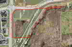
For a larger image of the site, please click HERE.
Anyone interested in the proceedings will be given an opportunity to be heard. Copies of the request are available for review in the Department of Planning and Development Services at Chesterfield City Hall, 690 Chesterfield Parkway West during weekdays between the hours of 8:30 a.m. and 4:30 p.m. If you should need additional information about this project, or for a list of requested uses, please contact Ms. Cassie Harashe, Project Planner, by telephone at 636-537-4745 or by email at CHarashe@chesterfield.mo.us
CITY OF CHESTERFIELD
Merrell Hansen, Chair
Chesterfield Planning Commission
PROPERTY DESCRIPTION
A tract of land being part in U.S. Survey 126, Township 45 North, Range 4 East of the Fifth Principal Meridian, City of Chesterfield, St. Louis County, Missouri, containing 11.1 acres, further described below:
Beginning at the southeastern corner of property conveyed to St. Louis County, Missouri, for the widening of Long Road, formerly 60 feet wide, by deed recorded in Deed Book 17849, Page 973 of the St. Louis County records, being a point on the northern line of property conveyed to the Monarch-Chesterfield Levee District by deed recorded in Deed Book 11721, Page 724 of the St. Louis County records, thence northeasterly, along the eastern line of said property conveyed to St. Louis County, North 01 degree 25 minutes 27 seconds East, 608.80 feet to its intersection with a point on the southern line of property conveyed to the City of Chesterfield for the widening of Long Road per Condemnation Suit Case No. 00CC003064 of the Circuit Court for St. Louis County according to “Notice of Payment of Condemnation Award” recorded in Deed Book 12841, Page 777 of the St. Louis County records; thence northeasterly and southeasterly, along the southern line of said property conveyed to the City of Chesterfield for the establishment of Edison Avenue according to the aforementioned condemnation suit, North 44 degrees 45 minutes 15 seconds East, 150.63 feet to a point; thence South 88 degrees 35 minutes 03 seconds East, 296.11 feet to a point on a curve; thence point; thence northeasterly, along a curve to the left having a radius of 635.37 feet, an arc a distance of 206.20 feet (North 80 degrees 09 minutes 22 seconds East, 205.29 feet on its chord) to a point on a curve on the south line of Adjusted Parcel 2 of the Boundary Adjustment Plat 4 of the Valley Center and part of Share 7 of the estate of Peter Steffan and part of Lot 1 of the Kroenung estate recorded in Plat Book 347, Page 13 of the St. Louis County records, thence southeasterly, along the southern line of adjusted Parcel 2, South 88 degrees 36 minutes 24 seconds East, 277.65 feet to a point; thence North 81 degrees 37 minutes 36 seconds East 67.01 feet to its intersection with a point on the eastern line of Lot 1 of the subdivision in partition of the Damian Kroenung estate, as aforementioned; thence northeasterly, along the southern line of said Adjusted Parcel 2, North 74 degrees 13 minutes 36 seconds East, 77.55 feet to a point, thence 83 degrees 54 minutes 36 seconds West, 243.10 feet to the southeastern corner of said Adjusted Parcel 2; thence southwesterly, along the eastern line of Share 7 of said subdivision in partition of the Peter Steffan estate, South 00 degrees 33 minutes 36 seconds West, 39.00 feet to a point; thence southwesterly, along the approximate centerline of Bonhomme Creek as located by Volz Engineering and Surveying, Inc., on October 30, 1981 according to Deed Book 7400, Page 312 of the St. Louis County records, South 86 degrees 14 minutes 47 seconds West, 224.88 feet to a point, thence South 80 degrees 58 minutes, 28 seconds West 105.00 feet to a point, thence South 62 degrees 32 minutes 26 seconds West, 75.00 feet to a point, thence South 27 degrees 52 minutes 42 seconds West, 217.00 feet to a point; thence South 39 degrees 43 minutes 19 seconds West, 326.00 feet to a point, thence South 32 degrees 55 minutes 15 seconds West, 103.00 feet to a point; thence South 15 degrees 11 minutes 37 seconds West, 88.00 feet to a point; thence South 27 degrees 52 minutes 25 seconds West, 84.12 feet to a point; thence southwesterly, along the northern line of property conveyed to Monarch-Chesterfield Levee District by deed recorded in Deed Book 11721, Page 724 of the St. Louis County records, South 89 degrees 58 minutes 47 seconds East, 456.51 feet to the point of beginning, containing 11.184 acres, more or less (487,188 square feet).