P.Z. 05-2014 18626 Olive Street Road (Simon Woodmont Development LLC)
NOTICE OF PUBLIC HEARING
CITY OF CHESTERFIELD
PLANNING COMMISSION
NOTICE IS HEREBY GIVEN that the Planning Commission of the City of Chesterfield will hold a Public Hearing on Wednesday, May 28, 2014 at 7:00 p.m. in the City Council Chambers at Chesterfield City Hall, 690 Chesterfield Parkway West, Chesterfield, Missouri63017.
Said Hearing will be as follows:
P.Z. 05-2014 18626 Olive Street Road (Simon Woodmont Development LLC): A request for a zoning map amendment from a “NU” Non-Urban District to a “PI” Planned Industrial District for 2.391 acres located southeast of the intersection of Olive Street Road and Spirit Valley East Drive (17W510060).
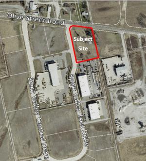
For a larger image of the site, please click HERE.
For a list of the requested uses, please contact the project planner.
Anyone interested in the proceedings will be given an opportunity to be heard. Copies of the request are available for review in the Department of Public Services at Chesterfield City Hall, 690 Chesterfield Parkway West during weekdays between the hours of 8:30 a.m. and 4:30 p.m. If you should need additional information about this project, please contact Mr. Jonathan Raiche, Senior Planner, by telephone at 636-537-4736 or by email at jraiche@chesterfield.mo.us
CITY OF CHESTERFIELD
Mike Watson, Chair
Chesterfield Planning Commission
Description of Property
A tract of land being Parcels 1 and 2 as described in a deed to Spirit Valley Development L.L.C. as recorded in Deed Book 17777, Page 3324 of the St. Louis County, Missouri Records excepting therefrom a tract of land conveyed to the City of Chesterfield, Missouri by a deed recorded in Deed Book 17773, Page 4337 of said Records, said tract being part of Lot 5 of the Amelia Boisselier Estate according to a plat thereof recorded in Plat Book 16, Page 27 of said Records and being part of U.S. Survey 368 in Township 45 North, Range 3 East of the Fifth Principal Meridian, City of Chesterfield, St. Louis County, Missouri and being more particularly described as follows:
BEGINNING at the Southeast corner of Parcel 2 of a tract of land described in a deed to Spirit Valley Development, L.L.C. as recorded in Deed Book 17777, Page 3324 of the St. Louis County, Missouri Records; thence along the Southern line of said Parcel 2 and the Southern line of Parcel 1 South 78 degrees 19 minutes 49 seconds West, a distance of 268.25 feet to the Southwest corner of the aforesaid Parcel 1, said point being on the Eastern line of Spirit Valley East Drive; thence along the Western line of said Parcel 1 North 11 degrees 25 minutes 51 seconds West, a distance of 237.02 feet to the intersection with the Eastern line of a tract of land conveyed to the City of Chesterfield, Missouri as recorded in Deed Book 17773, Page 4337 of the aforesaid St. Louis County Records; thence along said Eastern line the following: North 05 degrees 43 minutes 13 seconds West, a distance of 65.32 feet to a point; thence North 11 degrees 25 minutes 51 seconds West, a distance of 23.84 feet to appoint of curvature; thence along a curve to the right having a radius of 148.50 feet and an arc length of 48.98 feet to the point of tangency; thence North 07 degrees 28 minutes 03 seconds East, a distance of 23.43 feet to a point of curvature; thence along a curve to the right having a radius of 43.00 feet and an arc length of 48.85 feet to the intersection with the Southern line of Olive Street Road (60 feet wide); thence along said Southern line South 82 degrees 31 minutes 57 seconds East, a distance of 222.06 feet to the Northeast corner of the aforesaid Parcel 2; thence along the Eastern line of said Parcel 2 South 11 degrees 24 minutes 43 seconds East, a distance of 351.92 feet to the Point of Beginning and containing 104,161 square feet or 2.391 acres more or less as per calculations by Stock & Associates Consulting Engineers, Inc. during August, 2012.