P.Z. 03-2016 40 West Luxury Living (KU Development, LLC)
NOTICE OF PUBLIC HEARING
CITY OF CHESTERFIELD
PLANNING COMMISSION
NOTICE IS HEREBY GIVEN that the Planning Commission of the City of Chesterfield will hold a Public Hearing on Monday, May 23, 2016 at 7:00 pm, in the Council Chambers at the City Hall, 690 Chesterfield Parkway West, Chesterfield, Missouri 63017. Said Hearing will be as follows:
P.Z. 03-2016 40 West Luxury Living (KU Development, LLC): A request for a zoning map amendment from the “R-1” Residence District, “R-2” Residence District, and "NU” Non-Urban District to an “R-6” Residence District for a 14.296 acre tract of land located on the south side of South Outer 40 Road east of its intersection with Schoettler Road (19S640668, 19S640657, and 19S640152).
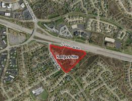
For a larger image of the site, please click HERE:
For a list of the Permitted Uses, please click HERE:
Anyone interested in the proceedings will be given an opportunity to be heard. Copies of the request are available for review in the Department of Public Services at Chesterfield City Hall, 690 Chesterfield Parkway West during weekdays between the hours of 8:30 a.m. and 4:30 p.m. If you should need additional information about this project, please contact Ms. Jessica Henry, Project Planner, by telephone at 636-537-4741 or by email at jhenry@chesterfield.mo.us
CITY OF CHESTERFIELD
Stanley Proctor, Chair
Chesterfield Planning Commission
PROPERTY DESCRIPTION
A tract of land being Lots 1 and 3 of Hay Barn Lane, a subdivision filed for record in Plat Book 179, page 77, Lots 1, 2 and 3 of Hay Wain, a subdivision filed for record in Plat Book 192, Page 1 and Adjusted Parcel 1 of the Boundary Adjustment Plat of part of U.S. Surveys 370, 1911, 1978 and Fractional Sections 10 and 15 as recorded in Plat Book 358, Pages 422 and 423 of the St. Louis County, Missouri records all being in Township 45 North, Range 4 East of the Fifth Principal Meridian, City of Chesterfield, St. Louis County, Missouri and being more particularly described as follows:
BEGINNING at a point on the Northeastern line of Schoettler Road being the Southwest corner of Lot 1 of Hay Barn Lane, a subdivision filed for record in Plat Book 179, Page 77 of the St. Louis County records; thence along the Northeastern line of Schoettler Road North 71 degrees 18 minutes 56 seconds West, 87.74 feet to a point; thence North 36 degrees 39 minutes 21 seconds West, 270.96 feet to the Westernmost corner of said Lot 1, said point being on the Southeastern line of Adjusted Parcel 1 of the Boundary Adjustment Plat recorded in plat Book 358, pages 422 and 423 of the St. Louis County records; thence along the Southeastern and Southwestern line of said Adjusted Parcel 1, being the Northeastern line of Schoettler Road the following: South 58 degrees 01 minutes 12 seconds West, 9.97 feet to a point; thence North 36 degrees 43 minutes 29 seconds West, 277.68 feet to a point; thence North 53 degrees 21 minutes 50 seconds East, 22.58 feet to a point; thence North 36 degrees 38 minutes 17 seconds West, 216.07 feet to a point; thence in a Northwesterly direction along a curve to the right having a radius of 436.44 feet, an arc length of 328.43 feet, the chord of which bears North 15 degrees 00 minutes 26 seconds West, a chord distance of 320.73 feet to a point on the Southern line of Missouri State Highway I-64, (also known as U.S 40); thence along said Southern line the following; South 63 degrees 46 minutes 26 seconds East, 18.15 feet to a point; thence South 75 degrees 40 minutes 48 seconds East, 147.26 feet to a point; thence South 76 degrees 23 minutes 16 seconds East, 253.14 feet to a point; thence North 48 degrees 19 minutes 32 seconds East, 79.01 feet to a point; thence South 76 degrees 50 minutes 28 seconds East, 52.59 feet to a point; thence South 75 degrees 54 minutes 06 seconds East, 221.76 feet to a point; thence South 44 degrees 21 minutes 13 seconds East, 62.43 feet to a point; thence South 84 degrees 52 minutes 38 seconds East, 200.35 feet to a point; thence South 75 degrees 37 minutes 48 seconds East, 226.83 feet to the Northeastern corner of Lot 3 of the aforesaid Hay Barn Lane; thence along the Northeastern and Southeastern lines of said Lot 3 the following: South 32 degrees 17 minutes 55 seconds East, 69.99 feet to a point; thence South 42 degrees 55 minutes 05 seconds West, 906.63 feet to the point of beginning and containing 622,717 square feet or 14.296 acres more or less as per a survey by Stock & Associates Consulting Engineers, Inc. during March, 2016.