P.Z. 07-2014 Clarkson Wilson Centre (2 Clarkson Wilson Centre)
NOTICE OF PUBLIC HEARING
CITY OF CHESTERFIELD
PLANNING COMMISSION
NOTICE IS HEREBY GIVEN that the Planning Commission of the City of Chesterfield will hold a Public Hearing on Monday, April 28, 2014 at 7:00 p.m. in the City Council Chambers at Chesterfield City Hall, 690 Chesterfield Parkway West, Chesterfield, Missouri 63017.
Said Hearing will be as follows:
P.Z. 07-2014 Clarkson Wilson Centre (2 Clarkson Wilson Centre): A request for an amendment to City of Chesterfield Ordinance 2547 to remove the restriction prohibiting amplified or live music once a year outside of enclosed structures within an existing “PC” Planning Commercial District for 5.17 acres located south of the intersection of Clarkson Road and Wilson Avenue (20T240171).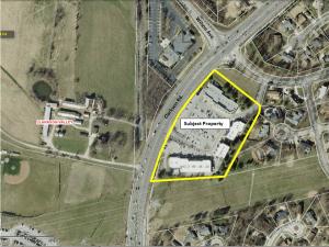
For a larger image of the site, please click HERE.
Anyone interested in the proceedings will be given an opportunity to be heard. Copies of the request are available for review in the Department of Public Services at Chesterfield City Hall, 690 Chesterfield Parkway West during weekdays between the hours of 8:30 a.m. and 4:30 p.m. If you should need additional information about this project, please contact Mr. John Boyer, Senior Planner, by telephone at 636-537-4734 or by email at jboyer@chesterfield.mo.us
CITY OF CHESTERFIELD
Mike Watson, Chair
Chesterfield Planning Commission
Description of Property
A tract of land in the North half of Section 21, Township 45 North, Range 4 East, St. Louis County, Missouri and being more particularly described as follows:
Beginning at a concrete monument marking the Southwestern corner of Clarkson Woods, Plat 2, as recorded in Plat Book 167 Page 66 of the St. Louis County Records, and also being a point on the Northern Line of Clarkson Woods South Plat 1 as recorded in Plat Book 166 Pages 94 and 95 of the said St. Louis County Records, thence South 27 degrees, 44 minutes, 50 seconds West along the Northern line of said Clarkson Woods South, Plat 1, a distance of 3.00 feet to a point; thence South 89 degrees, 48 minutes, 58 seconds West continuing along the said North line of Clarkson Woods South, Plat 1, a distance of 420.73 feet to a point said point being the Northwest corner of said Clarkson Woods South, Plat 1, and also being a point on the Eastern Right of Way line of Clarkson Road, 60 feet wide; thence along said Eastern line of Clarkson Road, along a curve to the right, having a radius of 1,402.69 feet, an arc distance of 705.00 feet to a point; thence leaving the said Eastern line of Clarkson Road along the North line of the existing C-8 zoning as established by Ordinance 6227 dated 1972, St. Louis County, Missouri, South 50 degrees, 01 minutes, 12 seconds East, a distance of 368.01 feet to a point on the Western line of the aforementioned Clarkson Woods Plat Two; thence along the Western line of Clarkson Woods, Plat 2, South 27 degrees, 44 minutes, 50 seconds West a distance of 419.45 feet back to the point of beginning.