P.Z. 05-2019 Chesterfield Ridge Center (Parcels VII and VIII)
NOTICE OF PUBLIC HEARING
CITY OF CHESTERFIELD
PLANNING COMMISSION
PLANNING COMMISSION
NOTICE IS HEREBY GIVEN that the Planning Commission of the City of Chesterfield will hold a Public Hearing on Monday, April 22, 2019 at 7:00 p.m. in the Council Chambers at Chesterfield City Hall, 690 Chesterfield Parkway West, Chesterfield Missouri 63017.
Said Hearing will be as follows:
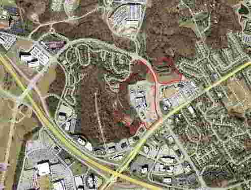
P.Z. 05-2019 Chesterfield Ridge Center (Parcels VII and VIII): A request for an ordinance amendment to the existing signage allocation in a “C-8” Planned Commercial District for parcels totaling 39.2 acres located along Chesterfield Parkway W north of Olive Blvd. (18S521119, 18S540138, 18S540149, and 18S540150)
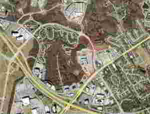
For a larger image of the site, please click HERE.
Anyone interested in the proceedings will be given an opportunity to be heard. Copies of the request are available for review in the Department of Planning & Development Services at Chesterfield City Hall, 690 Chesterfield Parkway West during weekdays between the hours of 8:30 a.m. and 4:30 p.m. If you should need additional information about this project, or for a list of requested uses, please contact Ms. Jessica Henry, Assistant City Planner, by telephone at 636-537-4741 or by email at jhenry@chesterfield.mo.us
CITY OF CHESTERFIELD
Merrell Hansen, Chair
Chesterfield Planning Commission
Property Description
A tract of land being Chesterfield Village, Northwest Quadrant, Parcel C314, a subdivision according to the plat thereof as recorded in Plat Book 346, Pages 377 and 378 of the St. Louis County Records, located in U.S. Survey 154, Township 45 North, Range 4 East of the Fifth Principal Meridian, City of Chesterfield, St. Louis County, Missouri being more particularly described as follows:
Beginning at the southeast corner of Parcel 314B of above said subdivision, said point also being located on the northern right-of-way line of Hilltown Village Center Street, variable width as established by Hilltown Village Center Parcel 318 Boundary Adjustment Plat, as recorded in Plat Book 353, Page 850 of above said records, said point also being located on a curve to the left having a radius of 369.28 feet; thence along said right-of-way line the following courses and distances: along said curve with an arc length of 55.19 feet and a chord which bears north 82 degrees 49 minutes 54 seconds west, 55.14 feet; south 82 degrees 36 minutes 53 seconds west, 57.40 feet to a point of curvature to the left having a radius of 369.44 feet; along said curve with an arc length of 62.54 feet and a chord which bears south 77 degrees 45 minutes 54 seconds west, 62.47 feet; south 72 degrees 54 minutes 50 seconds west, 189.73 feet to the point of non-tangential curve to the right having a radius of 250.90 feet; along said curve with an arc length of 107.42 feet and a chord which bears south 85 degrees 10 minutes 44 seconds west, 106.60 feet; north 83 degrees 49 minutes 10 seconds west, 59.33 feet to a point of curvature to the right having a radius of 94.70 feet; along said curve with an arc length of 100.10 feet and a chord which bears north 53 degrees 32 minutes 17 seconds west, 95.50 feet and north 23 degrees 15 minutes 21 seconds west, 15.59 feet to the eastern right-of-way line of Chesterfield Parkway West, 80 feet wide, said point also being located on a non-tangential curve to the left having a radius of 948.49 feet; thence along said curve with an arc length of 379.68 feet and a chord which bears north 25 degrees 8 minutes 20 seconds west, 377.15 feet; thence north 53 degrees 23 minutes 36 seconds east, 12.00 feet to the point of non-tangential curve to the left having a radius of 960.49 feet; thence along said curve with an arc length of 11.50 feet and a chord which bears north 36 degrees 56 minutes 59 seconds west, 11.50 feet to the northwest corner of Parcel C314 C of above said Chesterfield Village, Northwest Quadrant, Parcel 0314, subdivision; thence along the north line of said parcel 0314 C, north 52 degrees 43 minutes 25 seconds east, 444.01 feet to the northeast corner thereof; thence along the eastern lines of said Chesterfield Village, Northwest Quadrant, Parcel C314, subdivision, south 37 degrees 20 minutes 09 seconds east, 370.03 feet and south 49 degrees 18 minutes 34 seconds east, 280.38 feet to the easternmost corner of above said parcel C314 B; thence along the east line of said Parcel 0314 8, south 11 degrees 37 minutes 59 seconds west, 151.83 feet to the point of beginning. Containing 323,119 square feet or 7.418 acres, more or less.
And
A tract of land being Adjusted Parcel B of the Boundary Adjustment Plat of Lots 9 and 10 of the John Long Estates and Chesterfield Village Apartments Phase 3 in U.S. Surveys 123, 154 and 415, Township 45 North, Range 4 East, City of Chesterfield, St. Louis County, Missouri and being more particularly described as follows:
Beginning at a point on the south right-of-way line of Chesterfield Parkway North, said point being the northeast comer of Chesterfield Village Apartments Phase 3, a subdivision according to the plat thereof recorded in Plat Book 263, Pages 28 through 30 of the St. Louis County Records; thence along the south and southeast right-of-way line of Chesterfield Parkway North the following courses and distances: along a curve to the right whose radius point bears south 29 degrees 40 minutes 29 seconds west 914.93 feet from the last mentioned point, a distance of 368.24 feet, along a curve to the right whose radius point bears south 52 degrees 44 minutes 04 seconds west 868.49 feet from the last mentioned point, a distance of 659.65 feet, south 06 degrees 15 minutes 10 seconds west 106.28 feet, along a curve to the left whose radius point bears south 83 degrees 44 minutes 50 seconds east 905.89 feet from the last mentioned point, a distance of 566.75 feet and south 13 degrees 08 minutes 20 seconds west 68.35 feet to a point on the northwest right-of-way line of Olive Boulevard - Missouri State Highway a(340); thence along said northwest right-of-way line south 57 degrees 25 minutes 40 seconds west 15.95 feet and along a curve to the left whose radius point bears south 32 degrees 33 minutes 55 seconds east 1176.28 feet from the last mentioned point, a distance of 353. 71 feet to the northeast line of property conveyed to Chesterfield Village, Inc. by deed recorded in Deed Book 10795, Page 1959 of the St. Louis County Records; thence along said northeast line of Chesterfield Village, Inc. Property north 52 degrees 54 minutes 50 seconds west 114.28 feet to a point; thence along a curve to the right whose radius point bears north 61 degrees 33 minutes 31 seconds east 194.50 feet from the last mentioned point, a distance of 80.sl feet; thence along a curve to the left whose radius point bears south 00 degrees 53 minutes 13 seconds west 100.00 feet from the last mentioned point, a distance of 59.91 feet to a point; thence north 52 degrees 54 minutes 53 seconds west 40.63 feet to the northernmost comer of said Chesterfield Village, Inc. Property; thence along the northwest line of said Chesterfield Village, Inc. Property, south 36 degrees 19 minutes 46 seconds west 286.05 feet to a point; thence north 43 degrees 56 minutes 49 seconds west 675.55 feet along said northwest line of Chesterfield Village, Inc. Property and along the east line of said Chesterfield Village Apartments Phase 3; thence north 00 degrees 46 minutes 15 seconds east 500.00 feet to a point; thence north 32 degrees 29 minutes 57 seconds east 480.44 feet to a point; thence south 57 degrees 30 minutes 03 seconds east 60.00 feet to a point; thence north 32 degrees 29 minutes 57 seconds east 175.25 feet to a point; thence north 70 degrees 04 minutes 47 seconds east 85.42 feet to a point; thence north 02 degrees 28 minutes 17 seconds east 106.04 feet to a point; thence north 57 degrees 30 minutes 03 seconds west 59.04 feet to a point; thence north 32 degrees 29 minutes 57 seconds east 264.81 feet to the point of beginning and containing 31.785 acres more or less according to a survey by Volz, Inc. during July, 1998.