P.Z. 05-2023 Wings Corporate Estates, Lot 5
NOTICE OF PUBLIC HEARING
CITY OF CHESTERFIELD
PLANNING COMMISSION
Said Hearing will be as follows:

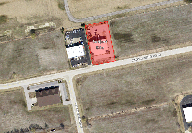
For a larger image of the site, please click HERE.
Anyone interested in the proceedings will be given an opportunity to be heard. Copies of the request are available for review in the Department of Planning at Chesterfield City Hall, 690 Chesterfield Parkway West during weekdays between the hours of 8:30 a.m. and 4:30 p.m. If you should need additional information about this project or for a list of requested uses, please contact Ms. Alyssa Ahner, Planner, by telephone at 636-537-4738 or by email at aahner@chesterfield.mo.us
CITY OF CHESTERFIELD
Guy Tilman, Chair
Chesterfield Planning Commission
PROPERTY DESCRIPTION
All of Lot 5 of Wings Corporate Estates, according to the plat thereof as recorded in Plat Book 356 page 79 of the St. Louis County Records, located in Township 45, Range 3 East of the Fifth Principal Meridian, City of Chesterfield, St. Louis County, Missouri, being more particularly described as follows:
Beginning at a found cut cross located on the centerline of Wings Corp[orate Drive, a 40 feet wide public roadway easement, according to the Wings Public Roadway Easement and Dedication Plat as recorded in Plat Book 357, page 427 of above said records, said point also being the southwestern corner of above said Lot 5, said point also being the southeastern corner of Lot 4 of said subdivision; thence along the common line between said Lots 4 and 5, North 11 degrees 31 minutes 12 seconds West, 329.88 feet to a found iron pipe located at the northwestern corner of said Lot 5; thence along the north line of said Lot 5; North 78 degrees 12 minutes 40 seconds East, 173.70 feet to a found iron pipe at the northeastern corner of said Lot 5, said point also being the northwestern corner of Lot 6 of said subdivision; thence along the common line between said Lots 5 and 6, South 11 degrees 31 minutes 12 seconds East, 329.88 feet to a found cut dross located at the centerline of above said Wings Corporate Drive; thence along said centerline, South 78 degrees 12 minutes 40 seconds West, 173.70 feet to the POINT OF BEGINNING.
Containing 57,300 square feet or 1.315 acres, more or less, according to calculations performed by Stock & Associates Consulting Engineers, Inc. on December 28, 2022.