P.Z. 03-2018 Spirit Valley Business Park (Ordinance Amendment)
NOTICE OF PUBLIC HEARING
CITY OF CHESTERFIELD
PLANNING COMMISSION
NOTICE IS HEREBY GIVEN that the Planning Commission of the City of Chesterfield will hold a Public Hearing on Monday, April 9, 2018 at 7:00 p.m. in the Council Chambers at Chesterfield City Hall, 690 Chesterfield Parkway West, Chesterfield, Missouri 63017.
Said Hearing will be as follows:
P.Z. 03-2018 Spirit Valley Business Park (Ordinance Amendment): A request to amend Ordinance 2745 to amend the height and setback restrictions for Lots 8 & 9B within an existing “PI” Planned Industrial District for a 52.82 acre tract of land located south of Olive Street Road and east of Wardenburg Road.
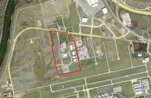
For a larger image of the site, please click HERE
.
Anyone interested in the proceedings will be given an opportunity to be heard. Copies of the request are available for review in the Department of Planning & Development Services at Chesterfield City Hall, 690 Chesterfield Parkway West during weekdays between the hours of 8:30 a.m. and 4:30 p.m. If you should need additional information about this project, or for a list of requested uses, please contact Ms. Cecilia Dvorak, Project Planner, by telephone at 636-537-4738 or by email at cdvorak@chesterfield.mo.us
CITY OF CHESTERFIELD
Merrell Hansen, Chair
Chesterfield Planning Commission
PROPERTY DESCRIPTION
A tract of land in St. Louis County, Missouri, being part of Lot 5 of the subdivision of Amelia Boisselier Estate, in U.S. Surveys 368, 1937 and 133, Township 45 North, Range 3 East, according to plat thereof recorded in Plat Book 16 Page 27 of the St. Louis County records, and a tract of land in U.S. Survey 153, Township 45 North, Range 3 East, being composed of two parcels, one marked "Cosmos Tamian Kroenung" and the other marked "Herman Schaeper and Agnes Schaeper" according to the plat accompanying Commissioner's Report in partition in estate of Valentine Kroenung, deceased, being Cause No. 16263 of the Circuit Court of the City (former County) of St. Louis, Missouri, in the year 1870, a copy of which report is recorded in Book 439 Page 448 of the records of said city, and being more particularly described as follows:
Beginning at a point on the southern line of Olive Street Road at the point of intersection with the western line of Lot 5 of the subdivision of the Amelia Boisselier Estate as recorded in Plat Book 16, Page 27 of the St. Louis County records; thence along the southern line of said Olive Street Road South 82 degrees 31 minutes 57 seconds East, a distance of 863.63 feet to the point of intersection with the western line of a tract of land described as Parcel 1 in a deed to Hornet Properties Inc., as recorded in Deed Book 10602, Page 2235 of the St. Louis County records; thence along said western line South 11 degrees 25 minutes 51 seconds East, a distance of 444.89 to the southern line of the aforesaid Lot 5; thence along said southern line and the prolongation thereof North 78 degrees 19 minutes 49 seconds East, a distance of 268.25 feet to northeast corner of a tract of land described as Parcel 2 in a deed to Paul N. Albrecht, Trustee, etal. as recorded in Deed Book 10392, Page 1830 of the aforesaid St. Louis County records; thence along the eastern line of said Parcel 2 of said Albrecht Tract South 11 degrees 24 minutes 44 seconds East, a distance of 1536.29 feet to a found iron rod at the southeast corner of said tract; thence along the southern line of said Parcel 2 of said Albrecht Tract South 78 degrees 12 minutes 13 seconds West, a distance of 1171.65 feet to the southwest corner of said tract; thence along the western line of said Parcel 2 of said Albrecht Tract North 12 degrees 24 minutes 49 seconds West, a distance of 117.14 feet to a stone at the southeast corner of Lot 3 of the aforesaid subdivision of the Amelia Boisselier Estate; thence continuing along the western line of the aforesaid Parcel 2 of said Albrecht tract, being the eastern line of said Lot 3, North 12 degrees 22 minutes 59 seconds West, a distance of 1421.85 feet to a stone at the northwest corner of the aforesaid Parcel 2 of said Albrecht tract; thence along the northern line of said tract North 78 degrees 19 minutes 49 seconds East, a distance of 112.42 feet to the southwest corner of the aforesaid Lot 5 of the subdivision of the Amelia Boisselier Estate; thence along the western line of said Lot 5 North 11 degrees 25 minutes 51 seconds West, a distance of 728.04 feet to the point of beginning and containing 2,300,839 sq. ft. 52.819 acres.