P.Z. 01-2019 Chesterfield Outlets (TSG Chesterfield Lifestyle, LLC)
NOTICE IS HEREBY GIVEN that the Planning Commission of the City of Chesterfield will hold a Public Hearing on Monday, March 11, 2019 at 7:00 pm, in the Council Chambers at the City Hall, 690 Chesterfield Parkway West, Chesterfield, Missouri 63017.
Said Hearing will be as follows:
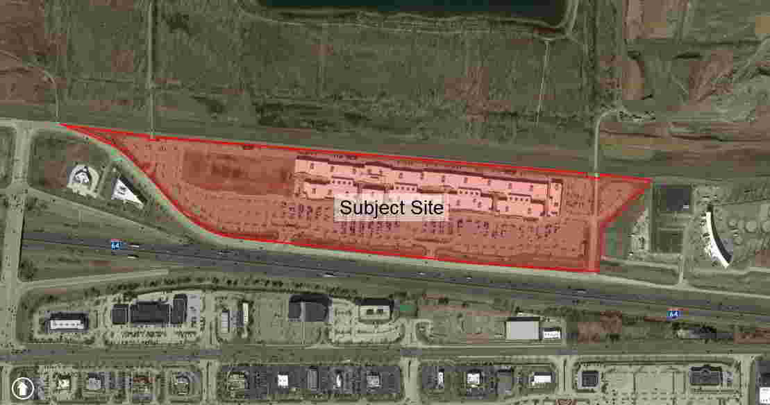
P.Z. 01-2019 Chesterfield Outlets (TSG Chesterfield Lifestyle, LLC): An ordinance amending City of Chesterfield Ordinance 2682 for a 48.125 acre tract of land located north of North Outer 40 Road and east of Boone’s Crossing. (17T420027)
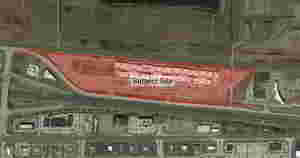
For a larger image of the site, please click HERE.
Anyone interested in the proceedings will be given an opportunity to be heard. Copies of the request are available for review in the Department of Planning and Development Services at Chesterfield City Hall, 690 Chesterfield Parkway West during weekdays between the hours of 8:30 a.m. and 4:30 p.m. If you should need additional information about this project, or for a list of requested uses, please contact Mr. Mike Knight, Planner, by telephone at 636-537-4736 or by email at JKnight@Chesterfield.MO.US
CITY OF CHESTERFIELD
Merrell Hansen, Chair
Chesterfield Planning Commission
PROPERTY DESCRIPTION
A tract of land being Adjusted Lot 1 of the Boundary Adjustment Plat of Lot 4 and 5 of the James Long's Estate and Part of Lots 1 and 2 of the Subdivision of Ludwell Bacon's Estate, and Lots 6, 7, 8 and 9 of Herman Ficke Estate Subdivision and a tract of land as conveyed to Taubman Prestige Outlets of Chesterfield, LLC by instrument recorded In Book 20516, Page 2999 of the St. Louis County records, located in U.S. Survey 2031, Township 45 North, Range 4 East of the Fifth Principal Meridian City of Chesterfield, St. Louis County, Missouri, being more particularly described as follows:
Beginning at the southeast corner of above said Adjusted Lot 1, South 01 degree 38 minutes 15 seconds West, 32.40 feet to the southeast corner of above said Taubman tract, said point being located on the north right-of-way line of North Outer 40 Road, variable width; thence along said right-of-way line the following courses and distances: North 84 degrees 18 minutes 34 seconds West, 260.09 feet to a point of curvature to the left having a radius of 5,020.50 feet; along said curve with an arc length of 117.62 feet and a chord which bears, North 84 degrees 58 minutes 50 seconds West, 117.62 feet; North 85 degrees 39 minutes 06 seconds West, 509.93 feet to a point of curvature to the right having a radius of 5,005.00 feet; along said curve with an arc length of 130.86 feet and a chord which bears, North 84 degrees 54 minutes 10 seconds West, 130.85 feet; North 84 degrees 09 minutes 13 seconds West, 1,030.57 feet; North 05 degrees 50 minutes 47 seconds East, 12.00 feet; North 84 degrees 09 minutes 13 seconds West, 389.67 feet to a point of curvature to the right having a radius of 668.00 feet and along said curve with an arc length of 123.52 feet and a chord which bears, North 78 degrees 51 minutes 23 seconds West, 123.34 feet to the southwestern corner of above said Adjusted Lot 1, said point also being located on the northeastern right-of-way line of said North Outer 40 Road; thence continuing in a northwesterly direction, along said right-of-way line and the western line of said Adjusted Lot 1, the following courses and distances: along said curve, with an arc length of 339.14 feet and a chord which bears North 59 degrees 00 minutes 53 seconds West, 335.51 feet; North 44 degrees 28 minutes 14 seconds West, 31.47 feet; North 42 degrees 33 minutes 41 seconds West, 359.33 feet; South 47 degrees 26 minutes 19 seconds West 6.47 feet; North 44 degrees 28 minutes 14 seconds West, 102.46 feet to a point of curvature to the left having a radius of 812.50 feet; along said curve with an arc length of 36.26 feet and a chord which bears, North 45 degrees 44 minutes 56 seconds West, 36.25 feet to a point of compound curvature to the left having a radius of 100.00 feet; along said curve with an arc length of 4.92 feet and a chord which bears North 48 degrees 26 minutes 15 seconds West, 4.92 feet to a point of compound curvature to the left having a radius of 805.52 feet; along said curve with an arc length of 268.82 feet and a chord which bears North 59 degrees 24 minutes 30 seconds West, 267.57 feet to a point of reverse curvature to the right having a radius of 100.00 feet; along said curve with an arc length of 3.90 feet and a chord which bears, North 67 degrees 51 minutes 02 seconds West, 3.90 feet to a point of reverse curvature to the left having a radius of 800.50 feet and along said curve with an arc length of 177.04 feet and a chord which bears, North 73 degrees 04 minutes 06 seconds West, 176.68 feet to its intersection with the west line of said Adjusted Lot 1; thence along said west line, North 00 degrees 21 minutes 46 seconds East, 18.67 feet to the northwest corner thereof; thence along the northern lines of said Adjusted Lot 1 the following courses and distances: South 84 degrees 50 minutes 26 seconds East, 75.65 feet; South 83 degrees 33 minutes 04 seconds East, 203.31 feet; South 83 degrees 57 minutes 15 seconds East 199.86 feet; South 85 degrees 08 minutes 30 seconds East, 70.09 feet; South 04 degrees 51 minutes 30 seconds West, 9.00 feet; South 85 degrees 32 minutes 19 seconds East, 99.85 feet; North 05 degrees 25 minutes 52 seconds East, 9.00 feet; South 84 degrees 34 minutes 08 seconds East 230.73 feet; South 84 degrees 33 minutes 54 seconds East 799.19 feet; South 84 degrees 35 minutes 06 seconds East, 699.37 feet; South 84 degrees 39 minutes 13 seconds East, 1,101.32 feet; South 84 degrees 23 minutes 27 seconds East, 81.27 feet; South 05 degrees 36 minutes 33 seconds West, 6.80 feet; South 84 degrees 38 minutes 09 seconds East, 119.38 feet; North 05 degrees 17 minutes 33 seconds East, 8.00 feet; South 84 degrees 42 minutes 27 seconds East, 95.20 feet; South 84 degrees 22 minutes 35 seconds East, 98.38 feet; South 87 degrees 39 minutes 27 seconds East 96.96 feet and North 85 degrees 20 minutes 22 seconds East, 14.76 feet to the northeastern comer of said Adjusted Lot 1; thence along the eastern and southeastern lines of said Adjusted Lot 1, the following courses and distances: South 07 degrees 30 minutes 12 seconds West 22.65 feet; South 50 degrees 31 minutes 21 seconds West, 99.71 feet; South 38 degrees 40 minutes 37 seconds West, 130.29 feet; South 43 degrees 35 minutes 48 seconds West, 119.08 feet; South 52 degrees 55 minutes 22 seconds West, 83.69 feet; South 66 degrees 52 minutes 23 seconds West 42.59 feet and South 01 degree 38 minutes 15 seconds West, 288.83 feet to the POINT OF BEGINNING. Containing 2,152,505 square feet or 49.415 acres, more or less, according to calculations performed by Stock & Associates Consulting Engineers, Inc. on January 30, 2019.