P.Z. 01-2015 Barat Academy Foundation (17815 & 17803 Wild Horse Creek Road):
NOTICE OF PUBLIC HEARING
CITY OF CHESTERFIELD
PLANNING COMMISSION
NOTICE IS HEREBY GIVEN that the Planning Commission of the City of Chesterfield will hold a Public Hearing on Monday, February 23, 2015 at 7:00 p.m. in the City Council Chambers at Chesterfield City Hall, 690 Chesterfield Parkway West, Chesterfield, Missouri 63017.
Said Hearing will be as follows:
P.Z. 01-2015 Barat Academy Foundation (17815 & 17803 Wild Horse Creek Road): A request for a zoning map amendment from a “LLR” Large Lot Residential District and “NU” Non-Urban District to a new “LLR” Large Lot Residential District for 35.097 acres located on the north side of Wild Horse Creek Road west of its intersection of Greystone Manor Parkway and east of its intersection with Tara Oaks Drive (18V140098, 18V140065).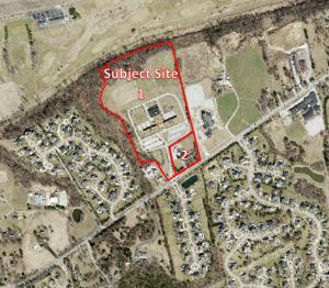
For a larger image of the site, please click HERE.
PERMITTED USES:
Residential:
Single-family detached
Civic:
Public safety facilities
Public:
Churches and other places of worship
Farming (including cultivation and sale of crops, plants and domestic animals with no salesrooms)
Home Occupation
Livestock and stables
Parks
Wildlife reservation, forest and conservation project
Educational:
College/University
Primary
Secondary
Kindergarten, Nursery School
Utilities:
Public facilities
Anyone interested in the proceedings will be given an opportunity to be heard. Copies of the request are available for review in the Department of Public Services at Chesterfield City Hall, 690 Chesterfield Parkway West during weekdays between the hours of 8:30 a.m. and 4:30 p.m. If you should need additional information about this project, please contact Mr. Jonathan Raiche, Senior Planner, by telephone at 636-537-4736 or by email at jraiche@chesterfield.mo.us
CITY OF CHESTERFIELD
Mike Watson, Chair
Chesterfield Planning Commission
PROPERTY DESCRIPTION
A tract of land in U. S. Survey 102, Township 45 North, Range 3 East, St. Louis County, Missouri.
AND
A tract of land being part of Adjusted Lot A of ”Boundary Adjustment Plat Of A Tract Of Land In U. S. Survey 102, Township 45, Range 3 East, St. Louis County, Missouri” as recorded in the St. Louis County Recorder of Deeds Plat Book 346, Pages 353 and 354.