P.Z. 18-2019 Clarkson Centre (2264 Clarkson Rd)
NOTICE IS HEREBY GIVEN that the Planning Commission of the City of Chesterfield will hold a Public Hearing on Monday, January 13, 2020 at 7:00 p.m. in the Council Chambers at Chesterfield City Hall, 690 Chesterfield Parkway West, Chesterfield Missouri 63017.
Said Hearing will be as follows:
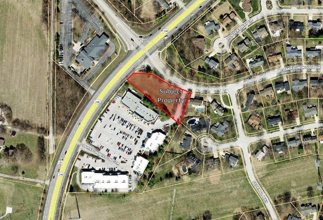
P.Z. 18-2019 Clarkson Centre (2264 Clarkson Rd): A change in zoning from “C-8” Planned Commercial District and “R-2” Residence District to a “R-4” Residence District for a 0.99 acre tract of land at 2264 Clarkson Road (20T610716).
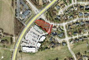
For a larger image of the site, please click HERE.
Anyone interested in the proceedings will be given an opportunity to be heard. Copies of the request are available for review in the Department of Planning at Chesterfield City Hall, 690 Chesterfield Parkway West during weekdays between the hours of 8:30 a.m. and 4:30 p.m. If you should need additional information about this project, or for a list of requested uses, please contact Ms. Annisa Kumerow, Planner, by telephone at 636-537-4743 or by email at akumerow@chesterfield.mo.us.
CITY OF CHESTERFIELD
Merrell Hansen, Chair
Chesterfield Planning Commission
PROPERTY DESCRIPTION
A tract of land in North 1/2 of Section 21, Township 45 North, Range 4 East, St. Louis County, Missouri and being more particularly described as follows:
Beginning at a point in the East and West Centerline of said Section 21, Township 45 North, Range 4 East; said point being distant Eastwardly along said East and West centerline North 89 degrees 48 minutes 58 seconds East 420.80 feet from the intersection of said East and West centerline with the East line of Clarkson Road, 60 feet wide; thence North 27 degrees 44 minutes 50 seconds East 42.45 to a rebar being the point of beginning; thence North 50 degrees 01 minutes 12 seconds West a distance of 368.01 feet to a cut cross on the Southern right of way line of Clarkson Avenue (60 feet wide); thence along an arc to the right having a radius of 1402.69 feet and a length of 50.40 feet with a chord bearing North 44 degrees 09 minutes 53 seconds East and a chord distance of 50.40 feet to a cut cross; thence South 86 degrees 08 minutes 26 seconds East a distance of 104.31 feet to a rebar being on the Southern line of Clarkson Woods Drive (60’ W); thence South 59 degrees 53 minutes 27 seconds East a distance of 137.00 feet to a point; thence along a curve to the left having a radius of 475.00 feet and a length of 151.44 feet with a chord bearing South 69 degrees 01 minutes 27 seconds East and a chord length of 150.79 feet to a cut cross; thence along a curve to the left having a radius of 20.00 feet and a length of 29.60 feet with a chord bearing South 60 degrees 21 minutes 38 seconds West and a chord length of 26.95 feet to a rebar; thence South 16 degrees 52 minutes 42 seconds West a distance of 149.62 feet to an iron pipe; thence South 27 degrees 44 minutes 50 seconds West a distance of 12.44 feet to the point of beginning and containing 41,231.5 square feet or 0.9 acres more or less.