P.Z. 13-2015 Chesterfield Valley Square (Burgundy Arrow LLC)
NOTICE OF PUBLIC HEARING
CITY OF CHESTERFIELD
PLANNING COMMISSION
NOTICE IS HEREBY GIVEN that the Planning Commission of the City of Chesterfield will hold a Public Hearing on Monday, January 11, 2016 at 7:00 p.m. in the City Council Chambers at Chesterfield City Hall, 690 Chesterfield Parkway West, Chesterfield, Missouri 63017.
Said Hearing will be as follows:
P.Z. 13-2015 Chesterfield Valley Square (Burgundy Arrow LLC): A request for a zoning map amendment from a “PI” Planned Industrial District to a “PC” Planned Commercial District for a 6.07 acre tract of land located on the south side of Chesterfield Airport Road west of Public Works Drive (17U230320).
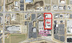
For a larger image of the site, please click HERE.
REQUESTED USES:
For a list of the Requested Uses, please click HERE.
Anyone interested in the proceedings will be given an opportunity to be heard. Copies of the request are available for review in the Department of Public Services at Chesterfield City Hall, 690 Chesterfield Parkway West during weekdays between the hours of 8:30 a.m. and 4:30 p.m. If you should need additional information about this project, please contact Mr. Jonathan Raiche, Senior Planner, by telephone at 636-537-4736 or by email at jraiche@chesterfield.mo.us
CITY OF CHESTERFIELD
Stanley Proctor, Chair
Chesterfield Planning Commission
PROPERTY DESCRIPTION
A tract of land being part of Share 3 and Share 4 of the Subdivision of the Estate of Peter Steffan in U.S. Surveys 125 and 126, Township 45 North, Range 4 East of the 5th Principal Meridian, St. Louis County, Missouri, and being part of Adjusted Parcel "A" of Boundary Adjustment Plat filed in Plat Book 216 Page 75 of the Recorder of Deed's Office in St. Louis County, Missouri, and being more particularly described as follows:
Beginning at the Northwest corner of above said Adjusted Parcel "A", said point also being located on the Southerly line of Chesterfield Airport Road, 100 feet wide; thence North 89 degrees 34 minutes 20 seconds East along last said Southerly line 263.79 feet to a point on a curve to the right for which the radius point bears South 08 degrees 00 minutes 45 seconds West 92.00 feet, said point also being located on the Southwesterly line of a tract of land as dedicated to the City of Chesterfield, Missouri for right-of-way by instrument recorded in Book 14205 Page 2994 of the above said Recorder's Office; thence along last said Southwesterly line along last said curve, with a chord which bears South 40 degrees 41 minutes 12 seconds East 121.44 feet an arc distance of 132.63 feet; thence departing last said curve South 00 degrees 34 minutes 15 seconds West 7.24 feet; thence South 89 degrees 25 minutes 45 seconds East 4.00 feet to a point on the Westerly line of Public Works Drive, 50 feet wide; thence South 00 degrees 34 minutes 00 seconds West along last said Westerly line 666.46 feet to a point on the Northerly line of a tract of land as conveyed to the City of Chesterfield by instrument recorded in Book 10559 Page 1471 of the above said Recorder's Office; thence South 89 degrees 34 minutes 20 seconds West along last said Northerly line 347.88 feet to a point in the Westerly line of above said Adjusted Parcel "A"; thence North 00 degrees 34 minutes 00 seconds East along last said Westerly line 766.46 feet to the POINT OF BEGINNING and containing 264,391 square feet or 6.070 acres more or less according to calculations performed by Stock & Associates Consulting Engineers, Inc. on March 25, 2004.