P.Z. 15-2016 17256 Wild Horse Creek Road (Lee’s Boys)
NOTICE OF PUBLIC HEARING
CITY OF CHESTERFIELD
PLANNING COMMISSION
NOTICE IS HEREBY GIVEN that the Planning Commission of the City of Chesterfield will hold a Public Hearing on Monday, January 9, 2017 at 7:00 p.m. in the City Council Chambers at Chesterfield City Hall, 690 Chesterfield Parkway West, Chesterfield, Missouri 63017.
Said Hearing will be as follows:
P.Z. 15-2016 17256 Wild Horse Creek Road (Lee’s Boys): A request for a zoning map amendment from a “NU” Non-Urban District to an “E-1” Estate District for a 4.2 acre tract of land located on the south side of Wild Horse Creek Road east of its intersection with Kehrs Mill Road (18U420027).
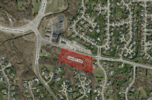
For a larger image of the site, please click HERE.
REQUESTED USES:
- Single-family detached dwelling
- Public safety facilities
- Churches and other places of worship
- Golf courses
- Home occupation
- Parks
- Wildlife reservation, forest and conservation project
- College/university
- Primary school
- Secondary school
- Kindergarten, nursery school
- Public facilities
Anyone interested in the proceedings will be given an opportunity to be heard. Copies of the request are available for review in the Department of Public Services at Chesterfield City Hall, 690 Chesterfield Parkway West during weekdays between the hours of 8:30 a.m. and 4:30 p.m. If you should need additional information about this project, please contact Ms. Jessica Henry, Senior Planner, by telephone at 636-537-4741 or by email at jhenry@chesterfield.mo.us
CITY OF CHESTERFIELD
Stanley Proctor, Chair
Chesterfield Planning Commission
PROPERTY DESCRIPTION
A tract of land in U.S. Survey 126, Township 45 North - Range 4 East, City of Chesterfield, St. Louis County, Missouri and being more particularly described as:
Beginning at the intersection of the West line of "Wildhorse Meadows", a subdivision according to the plat thereof recorded in Plat Book 346 pages 267 and 268 of the St. Louis County records with the North line of "The Crossing At Chesterfield", a subdivision according to the plat thereof recorded in Plat Book 346 pages 623 and 624 of the St. Louis County records; thence Westwardly along said North line of "The Crossing At Chesterfield", North 69 degrees 35 minutes 49 seconds West 754.41 feet to the East line of property described in deed to Hiu Cheung recorded in Book 21090 page 1247 of the St. Louis County records; thence Northwardly along the East line of said Cheung property, North 19 degrees 22 minutes 11 seconds East 235.99 feet to the South line of Wild Horse Creek Road, 80 feet wide; thence Eastwardly along said South line of Wild Horse Creek Road, 80 feet wide, the following courses and distances: South 72 degrees 42 minutes 18 seconds East 412.70 feet, along a curve to the left whose radius point bears North 17 degrees 17 minutes 42 seconds East 1472.69 feet from the last mentioned point, a distance of 203.91 feet and South 80 degrees 38 minutes 18 seconds East 39.44 feet to a point in the Northward prolongation of the West line of the aforesaid "Wildhorse Meadows"; thence Southwardly along said prolongation and the West line of said "Wildhorse Meadows", South 0 degrees 26 minutes 48 seconds West 309.56 feet to the point of beginning and containing 4.2 acres, more or less, according to calculations based on record information by Volz Incorporated on July 27, 2016.